| BUOY ROUNDUP
Sunday, September 20, 2026
:
- Buoy 239 (Lani)/Buoy 238 (Barbers Pt): Buoy 239 is Down - Using 238. Seas were 4.3 ft @ 16.7 secs with swell 2.3 ft @ 16.0 secs from 185 degrees. Water temp 81.9 (Barbers Pt), 81.9 (Pearl Harbor 233), NA (Lani 239).
- Buoy 187 (Pauwela): Seas were 6.6 ft @ 9.9 secs with swell 4.7 ft @ 8.2 secs from 85 degrees. Water temp 79.7 degs.
- Buoy 106 (Waimea)/Buoy 202 (Hanalei): Seas were 4.4 ft @ 7.1 secs with swell 3.3 ft @ 6.5 secs from 35 degrees. Water temp 80.2 degs, NA (Hanalei).
- Buoy 46025 (Santa Monica Basin): Seas were 2.7 ft @ 17.2 secs with swell 1.4 ft @ 17.7 secs from 228 degrees. Wind W 4-6 kts. Water temperature 72.7 degs, 65.7 (Harvest 071), 72.7 (Topanga 103), 72.7 (Long Beach 215), 73.8 (Oceanside Offshore 045), 73.2 (Del Mar 153), 73.6 (Torrey Pines Outer 100). At Harvest Buoy (071) primary swell was 4.4 ft @ 7.7 secs from 317 degrees. At E. Santa Barbara (46053) swell was 1.8 ft @ 6.4 secs from 262 degrees. At Santa Monica (028) swell was 1.1 ft @ 17.5 secs from 219 degrees. At Green Beach (271) swell was 1.1 ft @ 17.5 secs from 209 degrees. At Oceanside (045) swell was 1.1 ft @ 17.5 secs from 209 degrees. Southward at Pt Loma (191) swell was 1.5 ft @ 17.5 secs from 226 degrees. Water temperature 73.0.
- Buoy 029 (Pt Reyes)/Buoy 157 (Pt Sur): Seas were 6.0 ft @ 8.0 secs with swell 4.1 ft @ 7.7 secs from 325 degrees and southern hemi swell 1.8 ft @ 17.5 secs from 227 degrees. Wind northwest 12-16 kts (San Francisco 46026), NW 21-25 kts (Bodega Bay 46013), NW 14-16 kts (Half Moon Bay 46012) and NW 18-21 (Monterey Bay (46042). Water temp NA (Bodega Bay 46013), 60.6 (Pt Reyes 029), 59.2 (San Francisco 46026), NA (SF Bar 142), 60.1 (Half Moon Bay 46012), 61.0 (Monterey Bay 46042), 60.4 (Monterey Outer Canyon 156).
Swell Classification Guidelines
Significant: Winter - Swell 8 ft @ 14 secs or greater (11+ ft faces) for 8+ hours (greater than double overhead).
Summer - Head high or better.
Advanced: Winter - Swell and period combination capable of generating faces 1.5 times overhead to double overhead (7-10 ft)
Summer - Chest to head high.
Intermediate/Utility Class: Winter - Swell and period combination generating faces at head high to 1.5 times overhead (4-7 ft).
Summer - Waist to chest high.
Impulse/Windswell: Winter - Swell and period combination generating faces up to head high (1-4 ft) or anything with a period less than 11 secs.
Summer - up to waist high swell. Also called 'Background' swell.
Surf Heights for Hawaii should be consider 'Hawaiian Scale' if period exceeds 14 secs.
PACIFIC OVERVIEW
Current Conditions
On Sunday (9/20) in North and Central CA surf was thigh to waist high and weakly lined up coming from the northwest and warbled, uneven and mushed early. Protected breaks were thigh high and weakly lined up and soft and warbled early early. At Santa Cruz surf was waist to chest high on the sets and somewhat lined up with decent form and clean but inconsistent early. In Ventura County surf was flat to knee high on the sets and weak and very clean early. Central Orange County had sets at waist high on the sets mostly closing out on the inside just off the beach and clean early. South Orange County's best summertime breaks had rare individual set waves at head high weakly lined up with decent form and clean but soft early. North San Diego had sets at waist high or so and lined up and clean early. Oahu's North Shore was flat and clean early. The South Shore had sets at chest to head high and lined up with good form and clean early. The East Shore was getting tradewind generated easterly windswell at chest to shoulder high and chopped from moderate east trades.
See QuikCASTs for the 5 day surf overview or read below for the detailed view.
Meteorological Overview
On Sunday (9/20) Hawaii was getting southern hemi swell originating previously under New Zealand. That same swell was starting to show on the buoys in CA and is to build early in the workweek. And a tiny gale was in the Northern Gulf of Alaska producing 23 ft seas aimed east. And a tropical system just off Japan is to recurve northeast but die before reaching the dateline offering nothing. But at least it's a turn in the right direction.
See all the details below...
SHORT- TERM FORECAST
Current marine weather and wave analysis plus forecast conditions for the next 72 hours North Pacific Overview
Jetstream
On Sunday (9/20) a trough was over the Northern Gulf of Alaska being fed by 120 kts winds offering some support for gale formation. In the west the jet was fragmented and ill formed. Over the next 72 hours the Gulf trough is to persist while additional energy develops over North Japan on Wed (9/23) with winds 110-120 kts pushing east generally on the 45N latitude line extending east over the entirety of the North Pacific starting to looks like an early Fall pattern. Beyond 72 hours winds in that flow to build to 150 kts on Fri (9/25) in one pocket over the dateline and extending east on the 45N latitude line from Japan to nearly Vancouver Island but with no trough indicated. But by Sun (9/27) a trough is forecast starting to develop in that flow over the Gulf of Alaska wit winds 130 kts perhaps starting to support gale formation. A positive trend is possibly forecast.
Surface Analysis
No swell of interest was hitting the coast originating from the North Pacific.
Over the next 72 hours a gale previously in the Gulf of Alaska is to possibly provide small north angled swell (see North Gulf Gale below).
Also a tropical system off Japan is to recurve northeast starting Mon (9/21) but rapidly fade and gone before reaching the dateline on Wed (9/23). No meaningful swell to result (see Tropical Update below).
North Gulf Gale
On Sat AM (9/19) a small gael started to wrap up in the Northern Gulf producing northwest winds at 35 kts with one small pocket to 45 kts and seas building. In the afternoon northwest winds were pushing east at 35 kts with seas 23 ft at 51.5N 150W aimed southeast. On Sun AM 99/20) fetch was fading while lifting northeast from 30-35 kts and seas fading from 23 ft at 53.5N 143.5W aimed east. Tiny sideband swell is likely radiating southeast. The gale is to be fading while pushing into the Alaskan Coast in the evening.
North CA: Expect tiny swell arriving on Tues (9/22) building to 2.7 ft @ 12-13 secs later (3.0 ft). Swell fading Wed AM (9/23) from 2.7 ft @ 11-12 secs early (3.0 ft). Swell gone after that. Swell Direction: 310-315 degrees
North Pacific Animations: Jetstream - Surface Pressure/Wind - Sea Height - Surf Height
Tropical Update
Tropical Storm Dujuan on Sun AM (9/20) was 240 nmiles southwest of Tokyo Japan tracking northeast with winds 60 kts. Winds to build to minimal typhoon strength at 65 kts on Mon AM (9/21) positioned 60 nmiles west of Tokyo Japan tracking northeast. Dujuan is to start accelerating off to the northeast and fading from 60 kts Tues AM (9/22) with winds down to 30 kts Wed AM 99/23) half way to the dateline, and gone after that. No swell production of interest is forecast.
Tropical Storm Odalys was developing 1500 nmiles south of Pt Conception on Sun (9/20) with winds 40 kts and forecast slowly building while retrograding north and with winds to 75 kts on Tues (9/22) tracking east before tracking north again on Fri (9/25) with winds down to 65 kts perhaps interacting with another tropical system developing off mainland Mexico on Thurs (9/24) and that one tracking a more normal northwesterly heading. Odds low on this happening at this early date.
California Nearshore Forecast
(North CA is defined as the area north of the Golden Gate - Central CA from Pt Conception to the Golden Gate, and Southern CA everywhere south of Pt Conception).
- Mon AM (9/21) northwest winds to hold at 20+ kts for North CA focused on Cape Mendocino and 15 kts for Central CA. In the afternoon no real change is forecast. Windswell holding.
- Tues AM (9/22) the gradient builds back with northwest winds 20-25 kts solid for North CA and 10-15 kts for Central CA early. In the afternoon the gradient builds more with northwest winds 20-30 kts mainly over Cape Mendocino and 15 kts for all of Central CA. Windswell building.
- Wed AM (9/23) the gradient holds with northwest winds 20-25 kts for North CA and 15 kts for Central CA and 20 kts off the coast early. In the afternoon low pressure is to be in the North Gulf and well off North CA with northwest winds 20-25 kts for North CA and 10-15 kts for Central CA. Windswell fading slightly.
- Thurs AM (9/24) local low pressure pushes east off North CA with northwest winds fading from 15-20 kts for North CA and 10 kts for Central CA early. In the afternoon the low moves up to North CA with northwest winds 5-10 kts for North CA and northwest 15 kts for Central CA . Windswell fading fast.
- Fri AM (9/25) low pressure is to be off San Francisco with high pressure west of it producing northwest winds 20 for North CApe Mendocino but clam winds south of there to Monterey Bay then northwest 15 kts south of there. In the afternoon high pressure moves in with northwest winds 20-25 kts for North CA and 20 kts for Central CA,. Windswell building.
- Sat AM (9/26) a pressure gradient holds with northwest winds 20+ kts for North CA and 15 kts for Central CA. In the afternoon northwest winds to be 20 kts for North CA and 10 kts for Central CA. Limited windswell holding.
- Sun AM (9/27) northwest winds to be 15+ kts for North Ca and 15 kts for Central CA early. Windswell fading.
- - -
Tioga Pass/Pacific Crest Trail intersection forecast: Temps - Freeze Level
More locations here (scroll down to 'Resort Snow Forecasts>Central CA or North CA Caltrans & Backcountry')
Snow Models: http://www.stormsurf.com/mdls/menu_snow.html (Scroll down for Resort specific forecasts).
South Pacific
Overview
Jetstream
On Sunday (9/20) most wind energy was in the northern branch of the jetstream running flat east on the 28S latitude line and of no interest. The influential southern branch of the jet was ridging solidly southeast pushing from under New Zealand down over Antarctic Ice just south-southeast of New Zealand then tracking east on the 70S latitude line running the whole way across the South Pacific offering no support for gale formation. Over the next 72 hours no change is forecast. Beyond 72 hours starting Thurs (9/24) something that almost looks like a trough is to try and develop southeast of New Zealand barely reaching north to 60S and barely getting exposed on ice free waters, then collapsing on Fri (9/25) with the ridging pattern again setting up sweeping east all over Antarctic Ice across the width of the South Pacific offering no support for gael formation. There's some suggestion of something that almost looks like a trough trying to develop under New Zealand on Sun (9/27) being fed by 120-130 kts winds. But odds are likely low of this actually occurring. No support for swell producing gale development is forecast.
Surface Analysis
On Sunday (9/20) swell from a gale previously south of Tasmania and New Zealand was impacting Hawaii and starting to show on the buoys of CA (see Tasman Sea-New Zealand Gale below).
Over the next 72 hours no swell producing fetch of interest is forecast.
Tasman Sea-New Zealand Gale
A gale developed south of the Tasmania on Thurs AM (9/10) with 40 kt southwest winds and seas 35 ft at 58S 139E aimed northeast and in the NCal swell window at 219 degs and in the SCal window at 221 degrees. In the evening 40 kts southwest winds were due south of the Tasman Sea with seas 34 ft at 58.25S 153.25E aimed northeast and in the CA swell window (220-221 degs). On Fri AM (9/11) the gale was due south of New Zealand with southwest winds fading to 35 kts with seas fading from 31 ft at 51.25S 165E aimed east-northeast and impacting Auckland Island. In the evening 30-35 kts southwest winds were tracking northeast with seas 26 ft at 51S 175.25E aimed northeast. On Sat AM (9/12) fetch and seas were gone. Low odds of any meaningful swell resulting. Residual fetch developed Sun AM (9/13) just east of New Zealand with 35-40 kts south winds over a tiny area with seas 27 ft at 46.75S 173W aimed northeast. In the evening south winds lifting northeast at 35 kts with seas 28 ft over a tiny area at 43.5S 167W aimed northeast. Fetch was fading Mon AM (9/14) from 30-35 kts and seas 24 ft at 41S 165W aimed northeast. Fetch dissipated after that. Again, low odds of swell resulting.
Oahu: Swell continues Sun (9/20) fading from 2.2 ft @ 15-16 secs early (3.0-3.5 ft). residuals on Mon (9/21) fading from 2.2 ft @ 14 secs (3.0 ft). Dribbles on Tues (9/22) fading from 1.9 ft @ 12-13 secs early (2.0-2.5 ft). Swell Direction: 212 moving to 195 degrees
Southern CA: Swell builds some on Sun (9/20) reaching 1.4 ft @ 16-17 secs later in the day (2.5 ft). Swell continues on Mon (9/21) building to 1.8 ft @ 17 secs later (3.0 ft). Swell holds on Tues (9/22) at 2.0 ft @ 16 secs (3.0 ft). Swell fades on Wed (9/23) from 1.9 ft @ 15-16 secs early (2.5-3.0 ft). Swell fading Thurs (9/24) from 2.0 ft @ 14 secs (2.5-3.0 ft). Residuals fading on Fri (9/25) from 2.0 ft @ 13 secs (2.5 ft). Swell Direction: 220 moving to 210 degrees
North CA: Swell builds some on Sun (9/20) reaching 1.6 ft @ 16-17 secs later in the day (2.5 ft). Swell continues on Mon (9/21) building to 1.9 ft @ 17 secs later (3.0 ft). Swell holds on Tues (9/22) at 2.0 ft @ 16 secs (3.0 ft). Swell fades on Wed (9/23) from 1.9 ft @ 15-16 secs early (2.5-3.0 ft). Swell fading Thurs (9/24) from 1.9 ft @ 14 secs (2.5-3.0 ft). Residuals fading on Fri (9/25) from 1.6 ft @ 13-14 secs (2.0 ft). Swell Direction: 220 moving to 210 degrees
Another New Zealand Gale
A primer gale started to develop south of New Zealand Thurs AM (9/17) producing southwest winds at 35-40 kts with seas 27 ft at 52S 159.5E aimed east. In the evening west-southwest winds build to 45 kts over a tiny area free and clear of New Zealand with seas 27 ft at 53.75S 175E aimed east. On Fri AM (9/18) the gale was building while falling southeast with southwest winds 45 kts over a tiny area aimed northeast with seas 32 ft at 56.5S 171.25W aimed east. A new gale is to be building under Tasmania too. In the evening the new gale was taking over with 50 kts west winds south of the Tasman Sea and shadowed relative to California with 37 ft seas at 51.75S 152.25E aimed northeast pushing swell up into the Tasman Sea. On Sat AM (9/19) 45 kts southwest winds were due south of New Zealand with 38 ft seas at 51.5S 163E aimed east-northeast up the 222 degree path to Southern CA but shadowed relative to North CA. In the evening fetch was fading from 30-35 kts pushing up the southeast coast of New Zealand with seas fading form 28 ft at 52S 170E aimed northeast targeting North and Southern CA. Fetch was gone after that.
Oahu: Expect primer swell arrival on Thurs (9/24) building to 1.0 ft @ 15 secs later (1.5 ft). Swell builds Fri (9/25) to 1.3 ft @ 15-16 secs later (2.0 ft). Core swell arrives on Sat (9/26) building to 1.5 ft @ 16-17 secs later (2.5 ft). Swell holds on Sun (9/27) at 1.6 ft @ 15 secs (2.5 ft) through the day. Swell drops off Mon (9/28) fading from 1.6 ft @ 13-14 secs early (2.0-2.5 ft). Swell Direction: 217 moving to 205 and then 198 degrees
Southern CA: Expect swell arrival on Sun (9/27) building to 0.9 ft @ 17 secs later (1.5 ft). Mon (9/28) swell builds slightly to 1.3 ft @ 15-16 secs later (2.0 ft). Swell holds on Tues (9/29) at 1.3 ft @ 16-17 secs later (2.0 ft). Swell fades on Wed (9/30) from 1.5 ft @ 15-16 secs (2.0-2.5 ft). nothing after that. Swell Direction: 221 degrees
North CA: Expect swell arrival on Sun (9/27) building to 1.0 ft @ 17-18 secs later (1.5 ft). Mon (9/28) swell builds slightly to 1.6 ft @ 16-17 secs later (2.5 ft). Swell holds on Tues (9/29) at 1.0 ft @ 16-17 secs later (1.5-2.0 ft). Swell fades on Wed (9/30) from 1.3 ft @ 15-16 secs (2.0 ft). nothing after that. Swell Direction: 220 degrees
South Pacific Animations: Jetstream - Surface Pressure/Wind - Sea Height - Surf Height
LONG-TERM FORECAST
Marine weather and forecast conditions 3-10 days into the future North Pacific Beyond 72 hours a small gale is forecast just south of the Aleutians in the Northwestern Gulf with seas 24 ft at 51N 165W for 12 hours. Odds very low of this occurring. seas are to be approaching the dateline on Thurs (9/24) and 18 ft seas in the Central Gulf suggesting the North Pacific is to start showing signs of life. .
South Pacific
Beyond 72 hours no swell producing fetch of interest is forecast.
MJO/ENSO Forecast El Nino In Control Over the Equatorial Pacific
Large Kelvin Waves #3 and #4 Erupting off Ecuador - Kevin Wave #5 Backfilling the Warm Pool
In Nov '25 westerly anomalies associated with Active Phase of the MJO #1 took root producing a Kelvin Wave pushing warm subsurface waters east. In early January strong Active MJO #2 started producing a second WWB in the far West Pacific producing Kelvin Wave #2. Kelvin Waves #1 & #2 started impacted Ecuador in March. And in late Feb Active Phase #3 developed with strong west anomalies holding into 4/15. Large Kelvin Wave #3 started erupting over Ecuador early April. And another huge Westerly Wind Burst developed over the KWGA 5/17-8/2 setting up Kelvin Waves #4 that erupted in early July and #5 backfilling the warm pool in early Aug through Sept. Lower pressure is building over the dateline and high pressure is building over the Maritime Continent. A full turn to El Nino has set up over the equatorial Pacific, and likely strong. West anomalies were rebuilding 8/13 and forecast continuing non-stop for the foreseeable future.
MJO/ENSO Discussion
The Madden Julian Oscillation (MJO) is a periodic weather cycle that tracks east along the equator circumnavigating the globe. It is characterized in it's Inactive Phase by enhanced trade winds and dry weather over the part of the equator it is in control of, and in it's Active Phase by slackening if not an outright reversing trade winds while enhancing precipitation. The oscillation occurs in roughly 20-30 day cycles (Inactive for 20-30 days, then Active for 20-30 days) over any single location on the planet, though most noticeable in the Pacific. During the Active Phase in the Pacific the MJO tends to support the formation of stronger and longer lasting gales resulting in enhanced potential for the formation of swell producing storms. Prolonged and consecutive Active MJO Phases in the Pacific help support the formation of El Nino. During the Inactive Phase the jet stream tends to split resulting in high pressure and less potential for swell producing storm development. Wind anomalies in the Kelvin Wave Generation Area (KWGA) are key for understanding what Phase the MJO is in over the Pacific. The KWGA is located on the equator from 135E-170W and 5 degs north and south (or on the equator from New Guinea east to the dateline). West wind anomalies in the KWGA suggest the Active Phase of the MJO in the Pacific, and east anomalies suggests the Inactive Phase. In turn the Active Phase strengthens and the Inactive Phase weakens the jetstream, which in turn enhances or dampens storm production respectively in the Pacific.And the El Nino/La Nino cycle (collectively know as ENSO - El Nino Southern Oscillation) is a less frequent (about once every 7 years) but more impactful cycle that affects world wide weather. Specifically, strong El Nino events promote storm production in the Pacific while La Nina events suppress storm production. These therefore have a significant impact on the production of swell and surf. The paragraphs below analyze the state of the MJO and ENSO in the Pacific and provide forecasts for upcoming activity (or inactivity depending on the state and interaction of these two oscillations).
Longterm Swell Forecast Overview (updated 3/29/26): In 2022 La Nina evolved with easterly anomalies over the equatorial Pacific and cooler water at the surface off Ecuador. That pattern continued until late Fall 2022 when trades started fading and by early 2023 multiple Active Phases of the MJO produced several Westerly Wind Bursts (WWB) and Kelvin Waves pushing east resulting in significant oceanic warming over the East Equatorial Pacific. La Nina was dead on 3/18/2023 with El Nino apparently developing. But it was not coupled with the atmosphere by late July, and that spelled the demise of that event. There is growing suspicion the Hunga Tonga volcano eruption (1/15/2022) muted El Ninos impact. The fading of this El Nino only resulted in the buildup of more latent heat energy in the ocean. By Jan 2024 the first signs of the normal reaction to El Nino (failed or not) resulted, with La Nina emerging, but never developed more than Modoki status through Fall 2025. And then in Dec 2025, an Active Phase of the MJO developed with westerly anomalies producing a small Kelvin wave, followed by a slightly stronger one in Feb 2026. And then on March 8, westerly anomalies started building in earnest in the far West Pacific, building to strong status in late March suggesting something more was occurring. The buildup of latent heat energy in the planets ocean seems to ensure it will not be denied.
LONG-RANGE PACIFIC STORM AND SWELL GENERATION POTENTIAL FORECAST |
Fall/Winter 2026/2027 = 10.0 (California & Hawaii)
Rating based on a 1-10 scale: 1 being the lowest (small and infrequent surf conditions), 5 being normal/average, and 10 being extraordinary (frequent events of large, long period swells) |
Rationale: In the West Pacific a series of 3 Westerly Wind Bursts (WWB) occurred (Dec 26, Feb and then March 2026) with Kelvin Waves impacting Ecuador Feb 20, March 1, and then a big on on April 15. Then another WWB occurred starting 5/18 and continued non-stop through 8/3 producing 2 more huge Kelvin Waves (#4 erupting 7/5 and #5 erupting/backfilling the East Pacific warm pool starting 8/5). And a major westerly wind burst started again on 8/13 in the West Pacific and is to continue unchanged through at least Nov. The PDO is still weakly in the cool phase as of Aug 2026 but appears to be having no impact on the development of El Nino. A major El Nino is developing, possible stronger than '82 or '97 both of which are considered 'gold standard' events.
KWGA/Equatorial Surface Wind Analysis (KWGA - Kelvin Wave Generation Area - The area 5 degrees north and south of the equator from 135E to 170W - The main area for generating Kelvin Waves)
Analysis (TAO Buoys): As of (9/19) 5 day average winds were moderate east over the East Equatorial Pacific and moderate east over the Central Pacific and modest west over the dateline and moderate west over the KWGA. Anomalies were neutral over the East Pacific, moderate west over the Central Pacific, strong west over the dateline and strong west over the KWGA. (Note: These are 5 day average winds, versus realtime, so they lag what is happening today (by about 2.5 days).
2 Week Forecast (GFS Model): (9/20) Using CyclonicWX GFS 850 mb Zonal Wind Anomaly forecast: Moderate to strong west anomalies are over the KWGA today and forecast holding at moderate status through the end of the model run on 9/30. Actual west winds are blowing moderately over the dateline forecast holding into 9/24, then evaporating with weak east winds in control through 9/29, with west winds starting to redevelop over the East Pacific then through the end of the model run. The ECMWF model suggests essentially the same thing but stronger. Actual west winds are to hold in a thin band over the dateline through the end of the model run. The AI version of both models suggest west winds building over the KWGA 9/28 and beyond, possibly to strong status. An amazing run of westerly anomalies started May 18 persisted unchanged through 8/4 (2.5 months), then faded some. But a week later on 8/11 that pattern redeveloped and is forecast holding beyond.
Kelvin Wave Generation Area wind monitoring model: West and East
- MJO/WWB/Wind Projections:
OLR Models: (9/19) Currently a weak Inactive pattern (dry air) was depicted over the far west KWGA. The statistic model depicts an Inactive pattern holding filling 50% of the KWGA on day s 5-15 of the model run. The Dynamic model indicates a similar pattern. The Inactive MJO is having an effect, moderating El Nino.
Phase Diagrams - 2 week forecast (CA and GEFS): (9/20) - Today the models depicts the Active Phase was very weak over Africa. The statistic model has the Active Phase tracking east to the Central Indian Ocean and very weak 15 days out. The dynamic model indicates the Active Phase meandering east to the West Indian Ocean at the end of the model run and weak.
4 Week CFS Model (850 mb wind): (9/19) Today strong west anomalies were in control of the KWGA (since 8/13) with no contours indicated. The forecast indicates west anomalies to remain mostly strong the next 4 weeks but not as dense as previous the week of Oct 3-10. then rebuilding to previous density. This clearly suggests El Nino is strongly coupled with the atmosphere and the major mode of tropical variability, even with the Inactive MJO trying and make a stand.
3 Month CFS Model (850 mb wind): (9/19) - using the 5th ensemble member - the mean of the 4 individual members which are all from the 00Z run - 1 run per day):
Today moderate to strong west anomalies were in control of the KWGA centered on the dateline with an Inactive Phase starting to ease east targeting the dateline. Starting 9/20 west anomalies are to fade to modest status holding there into 10/1 as the Inactive Phase pushes over the dateline through 10/10. But west anomalies are to start rebuilding to strong status on 10/1. The Active Phase is transit the KWGA 10/6 through 11/11 driving the development of west anomalies at strong status 10/1-10/13 then very strong 10/14-11/1. An Inactive Phase is to return transiting the KWGA 10/19 through the end of the model run on 12/17 with west anomalies fading to moderate strength over that window. This is not as expected with the Inactive Phase suddenly forecast to make a stand. The low pass filter indicates the low pressure bias is filling the dateline region today with 6 contours (1st over the dateline 4/16, 2nd 6/12, 3rd on 7/9, 4th 7/26, and 5th 8/20 and 6th 9/13). The forecast builds from here forward with a 7th 10/19 holding through the end of the model run. The trailing/west edge of the high pressure bias is at 120W today with 1 contour and is to fade out in early Nov. A high pressure contour developed over the Maritime Continent at 70E on 6/13 and is to hold there for the foreseeable future building with a second contour on 9/16 and a third on 10/23. A wholesale pressure and wind pattern change has occurred over the equatorial Pacific and that pattern is strengthening day by day as we move into Fall and Winter. El Nino is here and building.
CFSv2 3 month forecast for 850 mb winds, MJO, Rossby etc - Alternate link
Subsurface Waters Temps
TAO data: Today (9/20) in the far West Pacific the leading east edge of the 30 degree isotherm was easing east from 140W to 139W, the 29 degree isotherm moving east from 125W to 124W. The 28 deg isotherm line had migrated almost the whole way across the Pacific (96W) then retrograded some, and has now moved from 107W to 105W today. An amazing push of warm water has moved east in sync with collapse of equatorial tradewinds and is holding today. The 24 deg isotherm had been thickening steadily while pushing into Ecuador down to 79m in June then rose to 69m in late July, but fell back to 79m early Aug then 82m, 90m (8/31) 96m (9/10) and and 92m today. Anomaly wise this strong change has been reflected down at the thermocline (-150m) Kevin Waves #4 and #5 erupting and backfilling into the warm pool with +4 deg anomalies or more tracking east from 165W and +10-+11 degs in it's core 100m down from 125W to Ecuador. Amazing. The hi-res GODAS animation posted 9/15 reflects this strong change too with a huge Kelvin Wave with +4 degs anomalies at the thermocline (-150m) pushing east from 170W into Ecuador and up to +6-7 degs in it's core from 150W to 80W and erupting to the surface in the Pacific east of the dateline. Warm anomalies continue filling the entire subsurface Pacific. The GODAS animation is 5 days behind the TAO data but also is more detailed and accurately depicted since it's satellite based.
Sea Level Anomalies: (9/15) Sea heights over most of the equatorial Pacific were positive from 175E pushing into Ecuador and radiating north and south along the South American Coast at +10-15 cms and north beyond San Francisco at +5-10 cms. Kelvin Waves #1, #2, #3 and #4 have already hit with Kelvin Wave #5 backfilling into the warm pool filling the entire Equatorial Pacific from Ecuador to 175E with a large area of +10 cms anomalies pushing east from 172W, +15 cms pushing east from 165W, +20 cm anomalies were filling the area from now 160W (previously 130W and before that 110W) to the Galapagos, +25 cms from 150 cms eastward, +30 cms from 138W eastward. And now a mind melting area of 35 cm anomalies were rebuilding filling the area from 122W east to 95W versus 115W to 90W in early Sept. Super impressive, and larger in coverage than it's previous peak. The entire equatorial West Pacific warm pool is 'sloshing' east creating a huge reservoir of warm water erupting over the Galapagos.
Upper Ocean Heat Anomaly Histogram (9/15) indicates warm anomalies at +2.5 degs C or more started filling a huge area over the East Pacific (from 155W early July) and continue today. +3.5 degree anomalies started at 140W on 7/15 building to 145W Aug 1, then contracted slightly mid-Aug to 135W, then returned to 145W Sept 1 and are holding there today. On December '25 warm anomalies and Kelvin Wave #1 started pushing east impacting Ecuador late Feb. Kelvin Wave #2 pushed east in Jan impacting Ecuador March 1. Kelvin Wave #3 started moving east late Feb impacting Ecuador 4/15. Kelvin Wave #4 developed the west mid-May hitting the preexisting warm pool on 7/7 building/backfilling it further to the west. And Kelvin Wave #5 appeared to be backfilling that on 8/1 arriving in the east on 8/15. And Kevin Wave #6 appears to be pushing east now. A clear sign of discharge was indicated in the west starting late March and stronger mid-April with deeper discharge was occurring over a small area at 155E 7/20 and stronger starting Sept 5. That said, actual water temps are 29-30 degs C in the West and only 27-28 in the East (+2 degs C difference offering more fuel for future Kelvin Wave development). That said - we are starting to approach the point where equilibrium is being reached.
Surface Water Temps
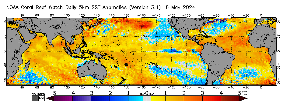
The more warm water in the equatorial East Pacific means more storm production in the North Pacific during winter months (roughly speaking). Cold water in that area has a dampening effect. Regardless of what the atmospheric models and surface winds suggest, actual water temperatures are a ground-truth indicator of what is occurring in the ocean. All data is from blended infrared and microwave sensors.
Satellite Imagery
Hi-res Nino1.2 & 3.4 Qualitative Analysis: (9/19) In the latest image a clear El Nino signal was present and expanding in coverage to the west. The area of super warm anomalies (4-5+ degs) were in place from Peru up off Ecuador west to the Galapagos and had expanded west of the Galapagos from 125W to 130W then 135W with a solid signal now expanding west to 148W today. Kelvin Wave #5 was backfilling into the subsurface Warm pool with Kelvin Wave #6 starting to arrive there too. Moderate warm anomalies were west of there to 175W and lesser warmth east to New Guinea. The ocean started showing clear signs of El Nino warming at the oceans surface in mid-March and coupled with the atmosphere now (3 months later mid-June). As of 8/28 images are beating the heat coverage at the surface for he same date in 1997. Amazing.
Hi-res 7 day Trend (9/19): No warming of interest was indicated. with a neutral trend in control of the equatorial Pacific.
Nino1.2 Daily CDAS Index Temps: (9/20) (The official OISST temps are 'corrected' to the most recent 30 year base period where this data is less aggressively corrected). Today's temps were down some at +4.070 after rising to +4.172 (9/17), up from +4.009 (9/10),.rising from +3.854 (9/8) +3.599 (9/3). Temps have been toggling +3.0-+3.9 since 7/14. Some points include +3.188 (8/28), +3.2904 (8/25), +3.604 (8/17), +3.9 (8/14), +3.738 (7/31) and +3.185 (7/20). Temps in general have been steadily rising. Previously temps were +0.010 (1/28) up from -0.320 (1/22). Temps had been rising 1/1-1/16, previously down at -1.596 12/30, up at -0.820 (12/20), that up from -1.453 4 days previous (12/19) but had been falling steadily since 12/2.
Nino 3.4 Daily CDAS Index Temps: (9/20) Today's temps were rising at +2.614 up slightly at +2.487 (9/17) up from +2.418 (9/10), +2.252 (9/3). Temps have been hovering at about +2.25 since 8/4 . Some points include +2.347 (8/25), +2.329 (8/17), +2.018 (7/21), +1.845 (7/16), +1.380 (7/4), +1.293 (6/26), 1.316 (6/28), +1.451 (6/21) and had been rising since 6/9, and rising before that steadily from 5/28 at +0.8 degs since (5/2), then +0.597 since 4/23, rising 10 days prior after reaching dead neutral (0.0) on 4/2, the first time in a very long time. Temps have been rising steadily since 1/11, at -1.267 12/27 falling from -0.922 (12/7), rising since 11/26.
Weekly RONI Anomalies were rising at +2.0 (9/9). steady at +1.8 (8/12, 8/19, 8/26 & 9/2). They were +1.7 (8/5), +1.6 (7/29), +1.4 RONI (week of 7/15 & 7/22), +2.0/+1.3 RONI (week of 7/8), +1.8/+1.2 (week of 7/1 and 6/24), +1.7/+1.1 (6/17), +1.5/0.9 RONI (6/10), +1.3/+0.7 (6/3), +1.0/+0.5 (5/20 & 5/27), +0.9 (4/29, 5/6 & 5/13), +0.4 the first 2 weeks and +0.5 (RONI).
Monthly ERSST RONI Data (ERSST) is +1.67 (Aug)., +1.33 July, +1.07 June +0.52 May, -0.13 April,
Seasonal ERSST 3 Month RONI is +1.36 (JJA), +0.97 (MJJ), +0.49 AMJ, -0.04 MAM, -0.44 FMA, -0.76 (JFM), -0.91 (DJF).
 |
 |
CFSV2 Forecast for Nino3.4 Sea Surface Temp (SST) Anomalies & Current SST Anomalies SST Anomaly Projections
CFSv2 Data (Nino3.4 Region)
Previous - Jan Relative temps were -1.0 turning neutral (0.0) in April +1.0 in June.
Forecast (9/14) - Temps are forecast rising dramatically from here forward. Raw forecast suggests temp peaking at +3.75 in early Nov (down from +4.45 8/17). The Relative forecast has temps peaking at +3.20 in early Nov (down from +3.75 degs 8/17). The 3 month forecast suggest temps peaking at +2.90 in OND. The 3 month PDF & Spread Corrected value is +2.10 (down from 2.4 on 8/17). It looks like we are moving into some flavor of 'Super' El Nino.
IRI Consensus Plume: The Aug 19, 2025 Plume (all models) depicts temps are rising fast at +2.0 today (July OBS). The Dynamic average suggest temps rising to +3.5 OND. The Statistic model suggests temps rising to +2.8 (NDJ). Relative temps to reach 3.35 degs NDJ. Per the average of all models, we are at minimal Strong El Nino status today and moving to Super status in the Fall.
See chart here - link.
Atmospheric Coupling (Indicating the presence of El Nino in the atmosphere driven by the ocean):
Southern Oscillation Index (SOI) (negative is good, positive bad - all but the Daily Index is a lagging indicator the 30 day average lagging 15 days and the 90 day average lagging 45 days):
The SOI is clearly indicating an El Nino signal.
Today (9/20) the Daily Index was -35.18, and has been almost exclusively negative since 3/25 and at times very negative (-30 or less). It dipped to -42.37 (9/19), -40.01 (7/15), -44.81 on 7/7.
The 30 day average was falling at -19.00 after previously peaking at -27.88 (8/1), -27.87 (7/20) and -23.61 (6/27). It rose to -13.18 (9/6) has been rising from -19.36 a month ago (due to the Inactive MJO in early Aug).
The 90 day average was falling slightly at -21.53 and previously peaked negative at -21.96 (8/6), -21.92 and -22.41 (8/21) after turning negative the first time in a very long time on 5/14 at -0.07. It was -22.39 a month ago. All this is incredible.
Pacific Decadal Oscillation (Negative is bad, Positive is good)
Past Recent History: The PDO theoretically turned from a warm (positive) trend in Spring of '98 and has cool (negative) mostly since then other than turning weakly positive March 2014-June 2017. It went hard negative in 10/2021-10/2023 driven by a 3 year La Nina conditions (down to -3.13). It started rising (but still negative) 11/2023-2/2024 driven by a strong El Nino, but not enough to even get it to break positive ground (best reading at -1.33 on 2/24). It then started falling in March 2024 down to -3.56 Sept (the lowest since April 1859) and -3.80 (Oct) the lowest ever reported. But in Nov the index final rose some to -3.13 and -2.03 in Dec 2024 and -1.29 in Jan 2025.
Current Situation: The index was steady at -1.11 Aug, -1.29 July, -1.32 June, -1.64 May, -1.28 April, March -1.44, Feb -1.01, Jan -1.26, Dec 2025 -0.96, -1.51 Nov, -2.37 Oct, -2.31 Sept (and in line with average readings since Nov 2021), -3.23 Aug after falling hard in July at -4.21 (the lowest ever), -2.64 June, -1.66 May, -1.15 April, -1.12 March and -1.45 Feb 2025. Looking at the long term record, it seems likely we are stable and still in the Cool Phase of the PDO (La Nina 'like') since 5/1998 with no sign of moving to the positive/warm phase (El Nino 'like') of any meaningful duration yet. We need at least 3 months of -1.2 or higher values before one could guess that maybe the cool phase is weakening.
See imagery in the ENSO Powertool
Local Interest
Stormsurf Video Surf Forecast for this week. See it Here
For automatic notification of forecast updates, subscribe to the Stormsurf001 YouTube channel - just click the 'Subscribe' button below the video. - - -
ESPN Sports Center 'Ride of a Lifetime' - The backstory of Alo Slebir's possible 100+ ft wave at Mevericks - https://www.youtube.com/watch?v=luQSYf5sKjQ
NBC News - Climate Change and Surfing: https://www.nbcnews.com/mach/science/climate-change-good-surfing-other-sports-not-so-much-ncna1017131
Mavericks & Stormsurf on HBO Sports with Bryant Gumbel https://www.youtube.com/watch?v=luQSYf5sKjQ Pieces Featuring Stormsurf:
http://www.bloomberg.com/video/how-to-predict-the-best-surfing-waves-EsNiR~0xR5yXGOlOq2MqfA.html
http://www.cbsnews.com/videos/surfs-up-for-mavericks-invitational-in-calif/ Time Zone Converter By popular demand we've built and easy to use time convert that transposes GMT time to whatever time zone you are located. It's ion left hand column on every page on the site near the link to the swell calculator. Surf Height-Swell Height Correlation Table |