Comparing Genesis of El Nino 1997 and the Current 2014 Westerly Wind Burst Events
Posted: Thursday April 3, 2014
There's been speculation regarding the formation of El Nino during this Spring of 2014. There was a minor relaxation of trades in the far West Equatorial Pacific during Dec 2013, followed by a series of three strong Western Wind Bursts (WWB) in Jan, Feb and March 2014 that have produce a large Kelvin Wave currently positioned south of Hawaii and presumably bound for Ecuador. At this time there are no clear signs of sea surface warming of the classic sense related to El Nino, and if anything a trickle of cooler water is flowing from North Peru west along the equator reaching to the Galapagos Islands, but making no headway and likely decaying, At at the same time a warm water regime is starting to set up across the entire length of the equatorial Pacific mostly due to warmer water just north of the equator pushing south to about 3S. So though there is warming, it does not appear to be associated with any direct affects from the aforementioned Kelvin Wave. A large reservoir of warmer than normal surface water is also pooled up in the North and West Pacific.
That said, the presence of a large Kelvin Wave with core water temperatures +5.0 deg C above normal as confirmed by the TOA Buoy array and sea surface heights above normal extending from west of the dateline to the Galapagos (exactly where the previous mentioned cool pool terminates), and a persistent negative Southern Oscillation Index suggest something of interest is occurring. All details concerning the current situation are discussed and updated 3 times weekly in the Pacific Surf Forecast (see ENSO subsection half way down the page) and can be monitored using this ENSO Powertool.
This situation is developing early in the year, and with much vigor, typical of the historically significant EL Nino's of '82/83 and '97/98 thus leading to speculation that it too might evolve into a strong ENSO event. Due to the voracity of the '82/83 event (the strongest of the century up to that time), and the global impacts it had both economically and at a human level, funding was secured to set up the TOA array in the equatorial Pacific to provide early warning of such events, and to provide a consistent data set from which to compare future events. It consists of 70 buoys straddling the equator from the Galapagos to west of the International Dateline and was constructed between 1985 and 1994, funded and maintained primarily by NOAA with assistance from Japan and France. There's been recent cuts in funding for NOAA and the array, resulting in delay of much needed maintenance, with many sensors in the East Pacific being offline. Fortunately maintenance is underway as of this writing, which will restore the array to full working order shortly. Regardless, there are some holes in the data.
Of note: Only the Kelvin Wave temperatures captured either at the 155W array and the closest easterly array at 110W can be confirmed. Any data between those two arrays is suspect (more on missing array sensors below). There are some models suggesting higher temperatures in this Kelvin Wave (+6.0 deg C) in the zone between arrays, but those are modeled, and not confirmed, and therefore are considered speculative.
The good news is there is sufficient coverage, especially regarding surface based sensors, that a respectable comparison of this potential event with the '97/98 event can be made.We draw no conclusions, because it it very early in the ENSO development process. As with anything nature related, the full process is not completely understood and what appears certain at this time can change in a moments notice. That is, projections in weather are just that, projections. Any forecasted weather event isn't real until it forms and its affects cause impact to people. So though it seems El Nino appears to be developing, there is no evidence of it yet in surface water temps off South America nor in the atmosphere. And any such evidence of it in the oceans surface is not expected for at least a month or more out, and not in the atmosphere until this Fall. Just the same, comparison is an interesting intellectual pursuit and worthy of the effort, if nothing more than helping to educate ourselves.
So here's the evidence as of today. We'll attempt to keep this updated as new data becomes available, roughly monthly. It all manually updated (no software auto updates) so we'll try to be as consistent as possible, and will post notices when updates are made.
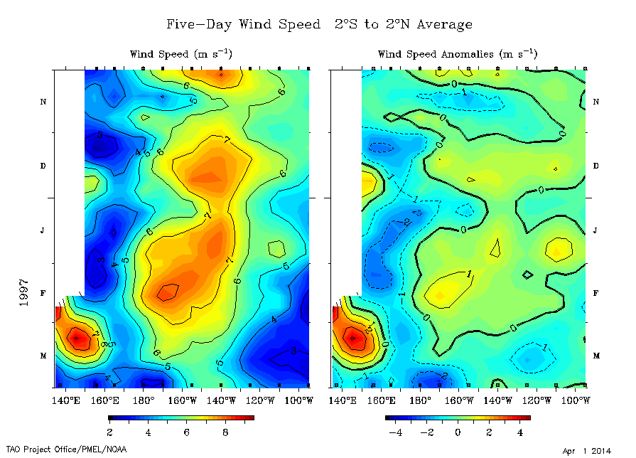
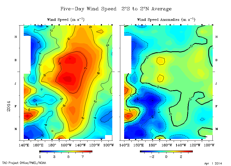
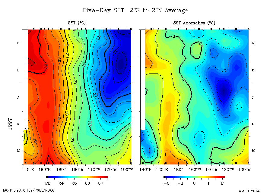
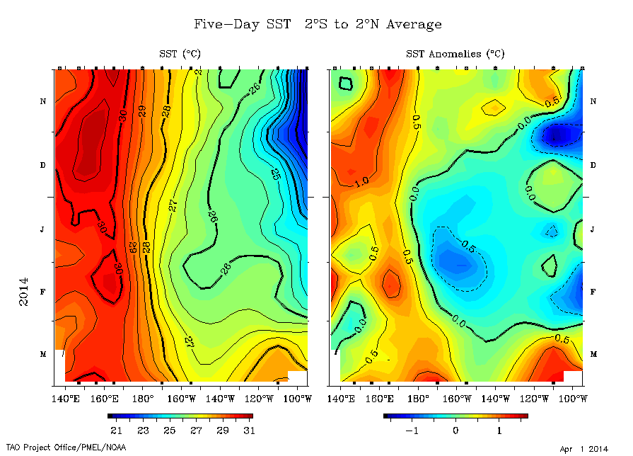
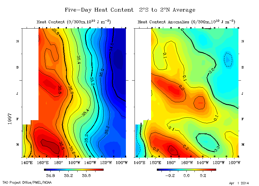
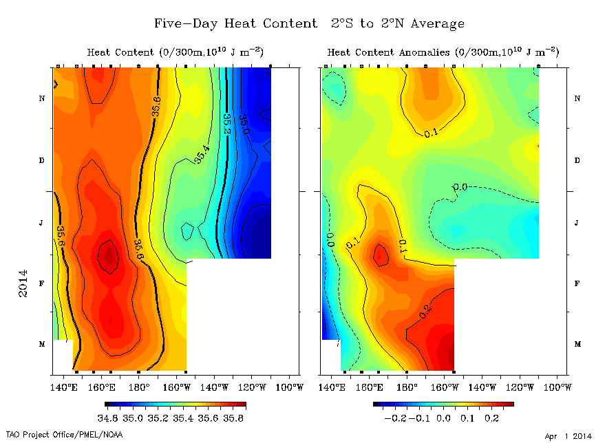
Image Explanation/How to Read: The vertical axis (left hand side of the image) is time, extending from November 1996 (or Nov 2013) (top) to recent time (March 31) (bottom). The horizontal axis (bottom of the image) are the coordinates of the equatorial Pacific Ocean, extending roughly from the far West Pacific (New Guinea) on the left to the far East Pacific (Galapagos Islands) on the right. Looking from the top of the image to the bottom one can view the evolution of variations and anomalies over the entire Pacific all in one image. The images on the left are actual temperatures or winds, and on the right are anomalies (departures from normal for that area and that time of year). It is the anomalies that define El Nino. There are two pairs of images for each section, one for the 1997 event, and one for the suspected 2014 event. Analysis for each section is provided below.
Wind Speed Blue colors indicate wind speeds below normal and reds are above normal. Relative to El Nino, the greater the reduction in winds speeds in the far West Pacific, the greater the likelihood that a Kelvin Wave will form. On the Anomaly Charts (right hand images) notice the significantly larger reduction of trades near the dateline starting in January in the 2014 image (lower image) as compared to the 1997 event (upper image). And in the 2009 El Nino wind speeds of -2.0 were never experienced to the magnitude of the 2014 event, and only approached that of the 1997 event in October.
----------
Sea Surface Temperature Red colors are warmer and blues are cooler. It is the anomaly charts (right hand images) that are of most interest. In both the '97 and 2014 events, warmer than normal waters started developing in early March along the equator presumably in response to decreased trades and/or WWB (Westerly Wind Bursts), mainly in the West Pacific (from the dateline west). But notice the comparatively larger area and warmer area associated with the 2014 event. Also notice the relatively large cool pool in the East Pacific in Dec '96/Jan 97 (-1.5 deg C) where a near neutral pattern was in play prior to the start of the 2014 event. This suggests less Kelvin Wave warming was required to push surface waters into the positive range. For comparison, during the 2009/10 El Nino anomalies of 0.5 or greater did not occur till mid-May.
----------
Heat Content These images depict the average heat content in the upper 300 meters of the oceans surface. The absolute heat content (left hand images) are pretty standard in that warm water is piled up in the West Pacific (35.8 deg C) with cooler waters in the east (34.8 C). Of most interest is the anomaly charts (right side). Notice that by March 2014 the developing warm pool was larger and appears to be warmer than during the '97 event at the same time. It's unfortunate sensors were down on the array in the far East Pacific in Feb and March 2014 preventing a further detailed inspection of that region. And for comparison, in the 2009/10 El Nino, anomalies of 0.2 or greater were not reached until late October (2009).
----------
Subsurface Water Temperature
Here is imagery depicting the subsurface migration and evolution of Kelvin Wave(s) that fuel El Nino. These images depict temperature anomalies (deviations from normal). The upper animation provides full month-by-month evolution of the 1997 event. The possible 2014 event is in the lower animation.
The start of the 1997 El Nino is delineated by a Kelvin Wave that developed in Nov 1996 in the far West Pacific (+2 deg C warmer than normal subsurface water temps) building to +4 deg C in Jan 1997 reaching to the Galapagos in February. That was quickly followed by a second Kelvin Wave in March under the dateline at +4 degs building to +5 degs in April and pushing east from there. Notice that by August subsurface water temps in the West Pacific were -3 degs C below normal, suggesting that all warm water available in the West Pacific was tapped out, setting the stage for the development of La Nina by the Spring of 1998.
The potential 2014 event started with a +2 deg Kelvin Wave in October 2013 (1 month earlier than the '97 event). That Kelvin wave attempted to make an impact in the East Pacific but did not evolve as strongly as the 1st wave of the '97 event. But, the 2014 event produced a second Kelvin wave starting in Jan (fueled by a strong WWB in Jan followed by a stronger second WWB in Feb) resulting in a large +4 deg Kelvin Wave in Feb which was up to +5 deg in March (fueled by yet a third WWB during that month).
The net result is from a subsurface perspective is that these two events are very similar in that they both had a Kelvin Wave occur the year before the calendar year they bloomed, but the 2014 Kelvin Wave materialized 1 month sooner than the first wave of the '97 event. And the second Kelvin Wave of the 2014 event also developed a month earlier than the second Kelvin Wave of the 1997 event. And the second Kelvin Wave of the 2014 event appears to be at least equal to if not stronger (more areal coverage and greater warmth) than the second wave of the 1997 event, even accounting for the 1 month lag.
All the above data suggests this evolving 2014 event is of equal strength to the 1997 event, if not stronger (as of the end of March 2014). The fact that the 2014 event started a month earlier might bias the analysis towards making it look stronger, if only in that it had more time to evolve. But the fact that it started a month earlier in and of itself could also suggest there was more latent heat energy built up in the ocean compared to the 1997 event. Note that El Nino is just a means for the ocean to vent off excess heat, serving much the same purpose as a hurricane relative towards venting off excess lower atmospheric heat. Also consider the continuous string of typhoons in the West Pacific (Philippines) during the Northern Hemisphere Summer of 2013, culminating in Super Typhoon Haiyan in early November 2013, a month after the first Kelvin Wave of the 2014 ENSO event developed and was tracking east under the equator toward Ecuador. Of note: Haiyan is the 4th strongest typhoon on record anywhere in the world, with the 3 above it all occurring in the '58-61 time frame. Conversely there is building evidence that suggest that wind speeds measured during typhoons from the '40s to the '60s (all in the West Pacific) were biased on the high side, potentially pushing Hiayan further up the all time ranking. Regardless, there is ample evidence to suggest a large warm pool was present in the West Pacific Ocean and was affecting the atmosphere above it. That oceanic warm pool heated the atmosphere above enough to suppress trades, if not cause an outright reversal of trades, generating a string of 4 WWBs, which ultimately resulted in the Kelvin Waves we are now tracking. Also consider that the '97 El Nino was the strongest on record (surpassing the '82/83 event) all causing significant global weather impacts to food production, transportation and human well being. and there is some evidence to suggest the earlier an El Nino forms, the stronger it will eventually be, all correlated to the same rationale above. At this time the evidence suggests a significant ENSO event is possible.
But, there is not one shred of evidence to suggest abnormal warming of surface waters off Ecuador is occurring. That is the trademark of El Nino. It is the warming of surface waters on the equator between 120W and 170W (commonly referred to as Nino 3.4) +0.5 deg C above normal for 3 or more consecutive months (exact parameters vary) that delineate the start of El Nino. And it takes another 3 months after that warm surface water manifests to start transferring energy into the atmosphere, enough so that the jet stream starts to increase velocity and change configuration affecting the track and strength of gales and storms below it, primarily focused on the North Pacific. One would not expect to see evidence of that until no earlier than late July 2014. And until that occurs, that is, the atmosphere is positively affected, this remains a 'potential' event. That said, this is a 'possible' event worth monitoring.
For real time monitoring of this situation (updates posted approx 3 times per week), visit our Pacific Ocean Surf Forecast Page (see ENSO subsection half way down the page) or for more advanced users monitor with the ENSO Powertool.