What is a storm? We've determined that swells are made by wind, and wind comes from storms. But what really is a storm? Well, let's start with some basics. Air covers the surface of our planet and has mass, that is, it has weight and volume, and it can be made to move. That's fairly obvious. But what causes it to move? Our atmosphere is dynamic, and it's temperature constantly changes in response to rotation of the planet, changes in seasons and earth's orbit around the sun. Why is temperature important? Because hot air is less dense than cold air, and when hot and cold air collide, the hot air is forced to rise over the colder air. Cold air typically is dryer than warm air and originates from our planet's poles. Warm air comes from the tropics/equator. Whenever cold dry air moves away from the poles, it eventually encounters warm wet air moving away from the equator. The warm wet air is forced up and over the cold air. When the warm air is forced up, it causes surface air pressure to drop, sort of like having a small vacuum develop at the earth's surface at the boundary between the two air masses. Cold air rushes in to fill the area of lower air pressure, which causes more warm air to be displaced upward, and more cold air moves in, forcing more warm air upward, and a cycle starts to develop. Also, factor-in that the earth rotates from west to east, dragging the atmosphere with it. The low-pressure area (also known as a low pressure center or system) starts to rotate, and all this moving air creates wind, and lots of it. In the north hemisphere, wind rotates counter-clockwise around a storm center, and clockwise in the south hemisphere (this driven by the Coriolis effect).
So a storm forms in response to an extreme difference in air pressure, driven by the movement of cold and warm air. Eventually either the cold or warm air dissipates, and equilibrium becomes re-established and calm, less-windy weather prevails. A storm can last as short as a few days to over a week. Our atmosphere is covered with areas of relatively high and low pressure, all driven by collisions between cold polar and warm equatorial air masses (for the most part). From a bird eye view, it is this difference in pressure between high and low-pressure systems that makes wind.
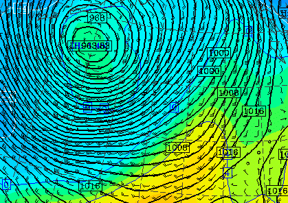
Storm Surface Pressure Image
An extreme difference in air pressure: 1016 mbs outside the storm center to 963 mbs in the center, 53 millibars of difference!
Image Courtesy: University of Washington
Our atmosphere likes equilibrium and dislikes differences is pressure. So when low pressure develops, air pours in to fill it. It's just like pulling the plug out of a bathtub full of water. The water from the tub rushes in to fill the hole in the drain. You might think the water is pulled down by gravity, but if the drain were already full of water, the water in the tub would stay put. In the atmosphere, rather than the air draining 'down', it drains 'up' towards the less dense environment of the upper atmosphere. Air moves from areas of relatively high pressure towards areas of relative low pressure to create equilibrium. The greater the pressure difference, the stronger the wind.
Surface air pressure can be measured by a device called a barometer. A barometer indicates pressure in units known as millibars (mbs) or inches of mercury. Without getting into the mechanics of how barometers operate, it's safe to say that barometers are the standard for measuring surface air pressure for weather purposes. If you live at sea level near the equator, standard 'normal' sea level air pressure would be about 1000 mbs. If a relatively strong high-pressure system were to move over your home, the barometer might indicate the pressure at around 1020 mbs. Conversely, if a strong low-pressure system were to move in, the barometer might register about 970 mbs. (Surface air pressure tends to be less as you travel north or go up in elevation). Of note, both high and low pressure systems typically cover at least many hundreds of miles in area, and move rather slowly. So you typically won’t see a change in pressure from one extreme to the other in a matter of hours, but more over a time periods of days or weeks. And it's highly doubtful you'll feel the change in air pressure, but you'll certainly see the weather changes associated with pressure change. Under high pressure, weather is typically fair, skies cloudless. But under low pressure, rain, wind and inclimate conditions prevail.
The greater the difference in air pressure between two competing systems, the greater the wind. And the greater the surface area covered by low pressure, the greater the size of the area of wind will be. Since strong wind is typically associated with storms, and since storms are characterized by low pressure, surf forecasters typically track and look for developing areas of low pressure, preferably large ones. The deeper or lower the pressure, the stronger the storm, the stronger the wind, and the greater the probability for surf to be generated. The larger the area of low pressure, the larger the fetch or ocean surface that will be affected by the resulting wind. Of course, to generate a large swell, the three requirements we discussed earlier must be met: High wind velocity, large fetch area, and long lasting winds. The ideal big wave set-up is to have a massive deep storm surrounded by extreme high pressure. And the systems must be positioned so that the fetch is aimed towards your beach for a long time. In reality, this rarely happens, but rather you get either a massive storm surrounded by relatively normal conditions, or a moderate storm surrounded by strong high pressure for a day or two at best.
So does this set-up look like? Funny you should ask…
NEXT |