|
|||
|
|||
|
|
|||
|
|||
|
South California Surf Report
This surf report contains buoy data and images that depict the current state of the ocean and atmosphere within the South California swell window. Use this page to track storms, observe arriving swells, and determine winds and tides at your beach.
Also see Buoy Data & Current Weather
About Powertools & Links
--All links on this page open a new window. When done viewing, just close the window--
Cams
| Location | Refresh Rate/Provider |
| Campus Point Santa Barbara | Real Time SiteCam |
| Ventura Point | Real Time Web.insidevc.com |
| Ventura | Periodically Truelook.com |
| Zuma Beach | Periodically watchthewater.co.la.ca.us |
| Malibu | Periodically watchthewater.co.la.ca.us |
| Venice Beach | Periodically watchthewater.co.la.ca.us |
| Manhattan Beach | Periodically watchthewater.co.la.ca.us |
| Hermosa Beach | Periodically watchthewater.co.la.ca.us |
| Redondo Beach | Periodically watchthewater.co.la.ca.us |
| Cabrillo Beach | Periodically watchthewater.co.la.ca.us |
| Hermosa Beach | Periodically watchthewater.co.la.ca.us |
| Pacific Palisades | One time daily. Pay for real-time Sunsetsurf.com |
| Laguna Beach | Real Time earthcam.com |
| San Clemente | Once Daily beach.com |
| Cardiff Reef | Real-time Hansensurf.com |
| Blacks | Real-Time Still Image Coastal Imaging Lab |
| Scripps Pier | Real-time Camzone.com |
| Crystal Pier/Pacific Beach San Diego | Real-time San-Diego-surfer |
| Pacific Beach | Report and pic SDsurfreport.com |
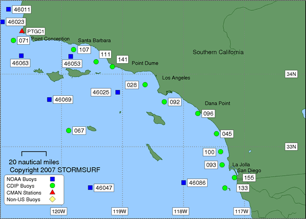
Buoy Overview Map
(Click on Buoy for More Data)
Courtesy: Scripps Research
Institute
 |
| Java Buoy Report (Scripps Research Institute) |
Stormsurf Buoys
(Click a buoy for detailed swell and surf data)
 |
Select Pacific Buoys
(Arranged in 'hit order' from
North to South)
For a complete list of Pacific Ocean buoys, click here
Current Observations Swell Forecast Buoy Number Buoy Name Primary Observation Secondary Observation Spectral Density of Current Observation 6 hr Hindcast & 180 hr Forecast
(NOAA OMB)CANADA
OffshoreTo view buoy locations select a Buoy Map: Buoy Map 1
Buoy Map 246184 N. Nomad NDBC Met Forecast 46004 Middle Nomad NDBC Met Forecast 46036 South Nomad NDBC Met Forecast US NW COAST
Well OffshoreTo view buoy locations select a Buoy Map: Buoy Map 1 46006 South Papa NDBC Wave Met Spec Dens Forecast Middle 46005 Washington NDBC Wave Met Spec Dens Forecast 46002 Oregon NDBC Wave Met Spec Dens Forecast NORTH & CENTRAL CA
OffshoreTo view buoy locations select a Buoy Map: Map 1 North
& South46059 California NDBC Wave Met Spec Dens Forecast Nearshore 46022 Eel River NDBC Wave Met Spec Dens Forecast 46030 Blunts Reef NDBC Wave Met Spec Dens Forecast 46014 Point Arena NDBC Wave Met Spec Dens Forecast 46026 San Francisco NDBC Wave Met Spec Dens Forecast 46012 Half Moon Bay NDBC Wave Met Spec Dens Forecast Santa Cruz (9 Band) SRI CDIP 46042 Monterey Bay NDBC Wave Met Spec Dens Forecast 46028 Central San Martin NDBC Wave Met Spec Dens Forecast 46062 Pt San Luis NDBC Wave Met Spec Dens Forecast Diablo Canyon (9 Band) SRI 46011 Santa Maria NDBC Wave Met Spec Dens Forecast 46023 Point Arguello NDBC Wave Met Spec Dens Forecast 46063 Pt Conception NDBC Wave Met Spec Dens Forecast Harvest (9 Band) SRI CDIP SOUTH CALIFORNIA
OffshoreTo view buoy locations select a Buoy Map: Buoy Map 1 San Nicholas Is. (9 Band) SRI 46025 Catalina RDG NDBC Wave Met Spec Dens Forecast 46047 Tanner Banks NDBC Wave Met Spec Dens Forecast Nearshore 46054 Santa Barbara W NDBC Wave Met Spec Dens Forecast 46053 Santa Barbara E NDBC Wave Met Spec Dens Forecast 46045 Redondo Beach NDBC Wave Met Spec Dens San Pedro (9 Band) SRI Santa Monica (9 Band) SRI Dana Point (9 Band) SRI Oceanside (9 Band) SRI Pt. La Jolla (9 Band) SRI Forecast SOUTHWEST TROPICAL PACIFIC (See N. Hawaii North Shore for buoy map) 51028 Christmas Island NDBC Wave Met Spec Dens Forecast
- SRI = Links to the Scripps Research Institute (SRI) data server for 9 band Directional Spectra
- CDIP = Links to the Coastal Data Information Program data server for Directional Spectra
- NDBC = National Data Buoy Center - Primary Source for Wave and Wind Observations
- Wave Met = Links to the NDBC FTP server which is often up when the prime web server is down.
Two links provided: One to detailed 'Wave' data, the other to 'Meteorlogical' data (including Significant Sea heights). Heights are in meters, Time in GMT/UTC. Field descriptions can be found here: Wave Met- Spec Dens = Links to the National Data Buoy Center. Dispalys the amount of energy in each spectral band by period.
- Buoy Forecast is from the Wavewatch III Wave Model courtesy of NOAA OMB.
Tabular display tracks up to 6 swells as they converge on any buoy simultaneously. Identifies Significant Wave Height, Swell Height, Period and Direction hourly for the previous 12 hours and 72 hours into the future. Wherever possible, the Regional Model is used to increase accuracy. Heights are in meters, Period in seconds. Direction indicates where the swell is heading. Add or substract 180 degrees to calcuate where it came from.
Spectral Density
(Dana Point CDIP Buoy)
 |
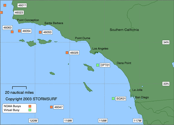
Directional Spectra Map
Courtesy: Coastal Data Information Program (CDIP)
Southern California
 |
San Pedro
 |
San Diego
 |
Swell Trend for Buoy 46025
Catalina RDG
Courtesy: National Data Buoy Center (NDBC)
Swell Height (in ft) & Period (in secs)
Wind Conditions via RUC2 Model
(updated every 3 hours)
Courtesy: NOAA FSL
 |
Northeast Pacific Satellite Image with
AVN Model Overlay
Courtesy: San Fracisco State University
 |
Full Pacific Satellite Image
Courtesy: Naval Research Laboratory
Click for full size image
 |
Northeast Pacific Ocean Surface Level
Pressure and Winds from the MM-5 Model
Courtesy: University of Washington
(Updated twice per day)
 |
Southern California Infrared
Satellite Image with Observation Overlay
Courtesy: San Francisco State University
 |
Current Global Winds Via WindSat Satellite Based Sensors
(Ascending Pass)
Courtesy: NOAA OPPT
 |
Local Marine Wind Conditions Via WindSat Satellite Based Sensors
(Ascending Pass)
Courtesy: NOAA OPPT
 |
Current 00hr NOAA Wave Model
(Uses NOAA Wavewatch III Wave Model)
Courtesy: Scripps Research
Institute
NE Pacific View
| Height | Period |
 |
 |
SE Pacific View
| Height | Period |
 |
 |
Current 00hr NOAA Wavewatch III Wave
Model
Courtesy: NOAA OMB
| Height | Period |
 |
 |
Stormsurf Buoy Forecasts
(Click a buoy for detailed swell and surf data)
 |
Tides
Courtesy: Biological Sciences: University of South
Carolina
3723
|
|||||||
|
|||||||
