|
|||
|
|||
|
|
|||
|
|||
|
Oregon and Washington Surf Report
This surf report contains buoy data and images that depict the current state of the ocean and atmosphere within the Oregon and Washington swell window. Use this page to track storms, observe arriving swells, and determine winds and tides at your beach.
Also see Buoy Data & Current Weather
About Powertools & Links
--All links on this page open a new window. When done viewing, just close the window--
| Java Buoy Report (Scripps Research Institute) |
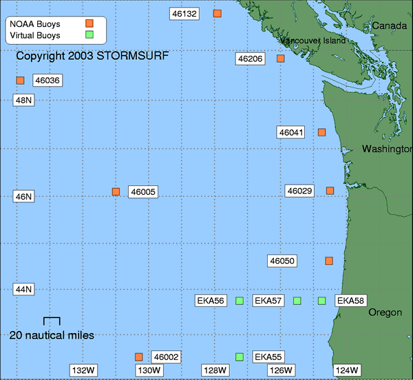
Stormsurf Buoys
(Click a buoy for detailed swell and surf data)

|
NW
Pacific Buoys
(Organized
in 'hit order' from North to South)
For a full list of Pacific Ocean buoys, click here
Current Observations Swell Forecast Buoy Number Buoy Name Primary Observation Secondary Observation Spectral Density of Current Observation 6 hr Hindcast & 180 hr Forecast
(NOAA OMB)ALASKA
OffshoreTo view buoy locations select a Buoy Map: Buoy Map 46066 South Aleutian NDBC Wave Met Spec Dens Forecast 46001 Gulf of Alaska NDBC Spec Dens Forecast Nearshore 46060 N. Prince William Sound NDBC Wave Met Spec Dens 46061 Prince William Sound NDBC Wave Met Spec Dens CANADA
OffshoreTo view buoy locations select a Buoy Map: Buoy Map 1
Buoy Map 246184 N. Nomad NDBC Met Forecast 46004 Middle Nomad NDBC Met Forecast 46036 South Nomad NDBC Met Forecast Nearshore 46205 W Dixon Entrance NDBC Met Forecast 46208 West Moresby NDBC Met Forecast 46147 South Moresby NDBC Met 46207 East Dellwood NDBC Met Forecast 46132 South Brooks NDBC Met Forecast 46206 La Perouse Bank NDBC Met Forecast US NW COAST
Well OffshoreTo view buoy locations select a Buoy Map: Buoy Map 1 46006 South Papa NDBC Wave Met Spec Dens Forecast Middle 46005 Washington NDBC Wave Met Spec Dens Forecast 46002 Oregon NDBC Wave Met Spec Dens Forecast Nearshore 46087 Neah Bay NDBC Wave Met Spec Dens 46041 Central Elizabeth NDBC Wave Met Spec Dens Forecast 46029 Columbia River Bar NDBC Wave Met Spec Dens Forecast Grays Harbour (9 Band) SRI 46050 Stonewall Bank NDBC Wave Met Spec Dens NORTH & CENTRAL CA
OffshoreTo view buoy locations select a Buoy Map: Map 1 North
& South46059 California NDBC Wave Met Spec Dens Forecast Nearshore 46027 St Georges NDBC Wave Met Spec Dens 46022 Eel River NDBC Wave Met Spec Dens 46014 Point Arena NDBC Wave Met Spec Dens Forecast SOUTH CALIFORNIA
OffshoreTo view buoy locations select a Buoy Map: Buoy Map 1 San Nicholas Is. (9 Band) SRI 46025 Catalina RDG NDBC Wave Met Spec Dens Forecast 46047 Tanner Banks NDBC Wave Met Spec Dens Forecast Nearshore Dana Point (9 Band) SRI SOUTHWEST TROPICAL PACIFIC (See N. Hawaii North Shore for buoy map) 51028 Christmas Island NDBC Wave Met Spec Dens Forecast
- SRI = Links to the Scripps Research Institute (SRI) data server for 9 band Directional Spectra
- CDIP = Links to the Coastal Data Information Program data server for Directional Spectra
- NDBC = National Data Buoy Center - Primary Source for Wave and Wind Observations
- Wave Met = Links to the NDBC FTP server which is often up when the prime web server is down.
Two links provided: One to detailed 'Wave' data, the other to 'Meteorlogical' data (including Significant Sea heights). Heights are in meters, Time in GMT/UTC. Field descriptions can be found here: Wave Met- Spec Dens = Links to the National Data Buoy Center. Dispalys the amount of energy in each spectral band by period.
- Buoy Forecast is from the Wavewatch III Wave Model courtesy of NOAA OMB.
Tabular display tracks up to 6 swells as they converge on any buoy simultaneously. Identifies Significant Wave Height, Swell Height, Period and Direction hourly for the previous 12 hours and 72 hours into the future. Wherever possible, the Regional Model is used to increase accuracy. Heights are in meters, Period in seconds. Direction indicates where the swell is heading. Add or substract 180 degrees to calcuate where it came from.
Spectral Density
(Buoy 46029)
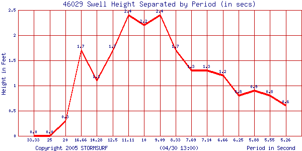 |
Swell Trend
for Offshore Buoy 46005
Courtesy: National Data Buoy Center NDBC
Swell Height (in ft) & Period (in secs)
North Hemipshere Surface Level
Pressure from the MRF Model
Courtesy: UNISYS/Purdue
(Updated once per day)
 |
Western
Washington Visible Satellite Image with Observation Overlay
Courtesy: San Francisco State University
 |
Western
Oregon Visible Satellite Image with Observation Overlay
Courtesy: San Francisco State University
 |
Wind
Conditions via the RUC Model
(updated every 3
hours)
Courtesy: NOAA FSL
 |
Northeast Pacific Ocean Surface Level
Pressure and Winds from the MM-5 Model
Courtesy: University of Washington
(Updated twice per day)
 |
Full Pacific Satellite Image
Courtesy: Naval Research Laboratory
Click for full size image
 |
Current
Global Winds Via QuikSCAT Satellite Based Sensors
(Ascending Pass)
Courtesy: NOAA OPPT
 |
Local
Marine Wind Conditions Via QuikSCAT Satellite Based Sensors
(Ascending Pass)
Courtesy: NOAA OPPT
 |
NOAA 00hr
Wavewatch III Wave Model
Courtesy: NOAA OMB
Full Pacific
| Height | Period |
 |
 |
North Pacific
| Height | Period |
 |
 |
Current
00hr SE Pacific NOAA Wave Model
(Uses NOAA Wavewatch
III Wave Model)
Courtesy: Scripps Research
Institute
| Height | Period |
 |
 |
Stormsurf Buoy Forecasts
(Click a buoy for detailed swell and surf data)
|
Tides
Courtesy: Tides On-Line NOAA
578
|
|||||||
|
|||||||
