|
|||
|
|||
|
|
|||
|
|||
|
Hawaii Surf Report
This surf report contains buoy data and images that depict the current state of the ocean and atmosphere within the Hawaiian swell window. Use this page to track storms, observe arriving swells, and determine winds and tides at your beach.
Also see Buoy Data & Current Weather
About Powertools & Links
Buoy
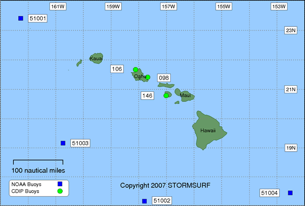
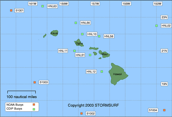
Overview Map
(Click on a buoy for
more detailed information)
Courtesy: Scripps Research
Institute
|
Stormsurf Buoys
(Click a buoy for detailed swell and surf data)
 |
Select Pacific
Buoys
For a
full list of Pacific Ocean buoys, click here
Current Observations Swell Forecast Buoy Number Buoy Name Primary Observation Secondary Observation Spectral Density of Current Observation 6 hr Hindcast & 180 hr Forecast
(NOAA OMB)ALASKA
OffshoreTo view buoy locations select a Buoy Map: Buoy Map 46066 South Aleutian NDBC Wave Met Spec Dens Forecast HAWAII
North ShoreTo view buoy locations select a Buoy Map: Buoy Map 51001 NW Hawaii NDBC Spec Dens Forecast 51003 Western Hawaii NDBC Spec Dens Forecast North Oahu
(22.0N - 157.75W)NORTH & CENTRAL CA
OffshoreTo view buoy locations select a Buoy Map: Map 1 North
& SouthNearshore 46012 Half Moon Bay NDBC Wave Met Spec Dens Forecast SOUTH CALIFORNIA
OffshoreTo view buoy locations select a Buoy Map: Buoy Map 1 San Nicholas Is. (9 Band) SRI 46025 Catalina RDG NDBC Wave Met Spec Dens Forecast 46047 Tanner Banks NDBC Wave Met Spec Dens Nearshore 46053 Santa Barbara E NDBC Wave Met Spec Dens Oceanside (9 Band) SRI Pt. La Jolla (9 Band) SRI Forecast HAWAII
S Shore (See N. Hawaii North Shore for buoy map)51004 Southeast Hawaii NDBC Wave Met Spec Dens Forecast 51002 Southwest Hawaii NDBC Wave Met Spec Dens Forecast South Oahu
(21.0N - 158.25W)SOUTHWEST TROPICAL PACIFIC (See N. Hawaii North Shore for buoy map) 51028 Christmas Island NDBC Wave Met Spec Dens Forecast Pago Pago (14.30S - 170.70W) Wake (19.50N - 166.50E)
- SRI = Links to the Scripps Research Institute (SRI) data server for 9 band Directional Spectra
- CDIP = Links to the Coastal Data Information Program data server for Directional Spectra
- NDBC = National Data Buoy Center - Primary Source for Wave and Wind Observations
- Wave Met = Links to the NDBC FTP server which is often up when the prime web server is down.
Two links provided: One to detailed 'Wave' data, the other to 'Meteorlogical' data (including Significant Sea heights). Heights are in meters, Time in GMT/UTC. Field descriptions can be found here: Wave Met- Spec Dens = Links to the National Data Buoy Center. Dispalys the amount of energy in each spectral band by period.
- Buoy Forecast is from the Wavewatch III Wave Model courtesy of NOAA OMB.
Tabular display tracks up to 6 swells as they converge on any buoy simultaneously. Identifies Significant Wave Height, Swell Height, Period and Direction hourly for the previous 12 hours and 72 hours into the future. Wherever possible, the Regional Model is used to increase accuracy. Heights are in meters, Period in seconds. Direction indicates where the swell is heading. Add or substract 180 degrees to calcuate where it came from.
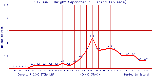
Spectral Density
(Waimea Bay Buoy)
 |
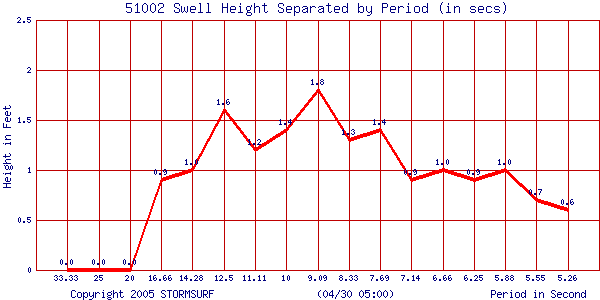
Spectral Density
(Buoy 51002)
 |
Swell Trend
for Northwest Hawaii Buoy 51101
Courtesy: National Data Buoy Center NDBC
Swell Height (in ft) & Period (in secs)
| Coastal
Conditions (updated every 3 hours) |
Northern Hemisphere
IR Satellite Image
Courtesy: NWS Western Region Headquarters
 |
West
Pacific GMS-5 IR Satellite Image
Courtesy: NOAA
 |
East Pacific Infrared GOES-10
Satellite Image
Courtesy: NOAA
 |
Hawaiian
Infrared Satellite Image
(Click Image to
Enlarge)
Courtesy: GOES NOAA
 |
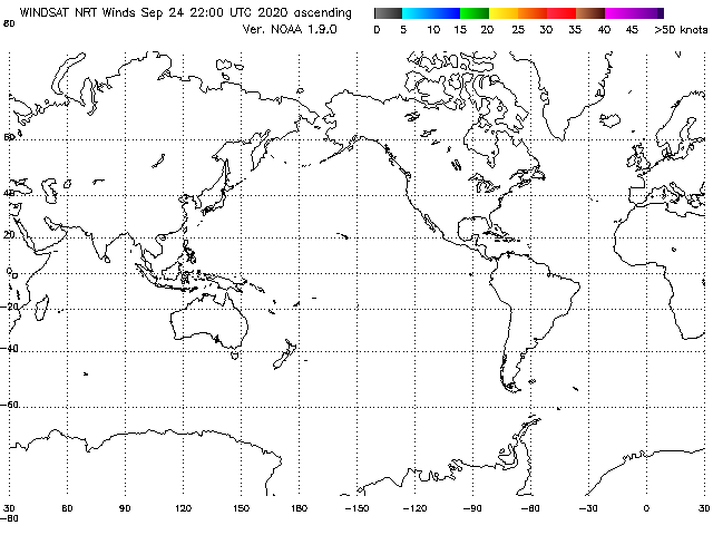
Current Global
Winds Via QuikSCAT Satellite Based Sensors
(Ascending Pass)
Courtesy: NOAA OPPT
 |
Local Marine Wind Conditions Via QuikSCAT Satellite Based Sensors
(Ascending Pass)
Courtesy: NOAA OPPT
 |
North Hemipshere Surface Level
Pressure from the MRF Model
Courtesy: UNISYS/Purdue
(Updated once per day)
 |
00hr NOAA
Wave Model
Courtesy: Scripps Research Institute
(Updated twice daily at 10Z and 22Z)
NW Pacific View
| Height | Period |
 |
 |
SE Pacific
View
Courtesy: Scripps Research Institute
| Height | Period |
 |
 |
NOAA 00hr
Wavewatch Wave Model - North Pacific View
Courtesy: NOAA OMB
| Height | Period |
 |
 |
Stormsurf Buoy Forecasts
(Click a buoy for detailed swell and surf data)
 |
Tides
Courtesy: Biological
Sciences: University of South Carolina
| Honolulu, Oahu | Mokuoloe,Kaneohe Bay, Oahu |
| Kawaihae, Big Island | Kailua Kona, Hawaii |
| Nawiliwili, Hawaii | Hilo, Hawaii |
| Kahului, Hawaii | Kihei, Maui |
| Kaunakakai, Molokai |
591
|
|||||||
|
|||||||

