British Isle Surf Report
Page 2
![]()
British Isle Surf Report
Page 2
[an error occurred while processing this directive]
| Home - Tutorials - Pacific Surf Forecast - El Nino Forecast - Create Your Own Forecast - Swell Calculator - Shop |
This surf report contains buoy data and images that depict the current state of the Atlantic Ocean and atmosphere within the British Isle swell window. Use this page to track storms, observe arriving swells, and determine winds and tides at your beach.
Also see Buoy Data & Current Weather
About Powertools & Links
**Links open a new window. When finished viewing, close the window and select another**
QuikSCAT Surface
Winds
Courtesy: NOAA OPPT
(Descending Satellite Pass)
 |
Local Marine
Wind Conditions via QuikSCAT Satellite Based Wind Sensors
Courtesy: NOAA OPPT
(Descending Satellite Pass)
 |
North Atlantic
NOAA Wave Model
Sea Height/Swell Vector/Period
(Uses Wavewatch III Model)
Courtesy: Scripps Research
Institute
| Height | Period |
 |
 |
North Atlantic
00hr NOAA Wavewatch III Model
(Updated 2 times daily at 6Z and 18 Z)
Courtesy: NOAA OMB
| Height | Period |
 |
 |
Northeast
Atlantic NOAA Wave Model
Sea Height/Swell Vector/Period
(Uses Wavewatch III Model)
Courtesy: Scripps Research
Institute
| Height | Period |
 |
 |
Winds at 850 mbs
from MRF Model
(Updated once daily at 00Z)
Image Courtesy: IGES/COLA
 |
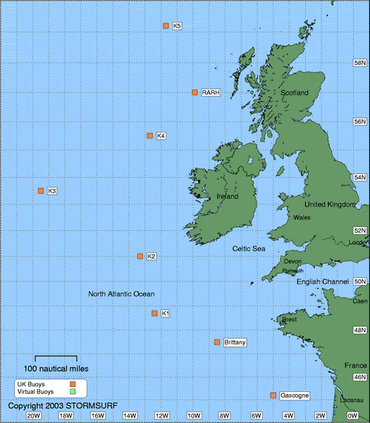
Stormsurf Buoy Forecasts
(Click a buoy for detailed swell and surf data)
|
2478
Comments?
webmaster@stormsurf.com
Last Modified: 08/04/01 09:35 PM