|
|||
|
|||
|
|
|||
|
|||
|
British Isle Surf Report
This surf report contains buoy data and images that depict the current state of the Atlantic Ocean and atmosphere within the British Isle swell window. Use this page to track storms, observe arriving swells, and determine winds and tides at your beach.
Also see Buoy Data & Current Weather
About Powertools & Links
**Links open a new window. When finished viewing, close the window and select another**
Surf Cameras
| Location | Refresh Rate/Provider |
| Every spot you can think of | Real Time A1surf.com |
| Bournemouth Report | Bournemouth-surfing.co.uk |
| Croyde | Croyde-surf-cam.com |
| Fistral Beach, Cornwall | Every few minutes Newquay-hotels.co.uk |
| Hayling Island | Periodically - Select this 'Surf Cam' option from this page |
| Saunton & Croyde | Daily Surfstation.co.uk |
| St Ouens | Near real-time thebeachjersey.com & cisurf.com |
| Woolacombe, Combesgate, Putsborough | Every 15 minutes Eyeball-surfcheck-webcam.co.uk |
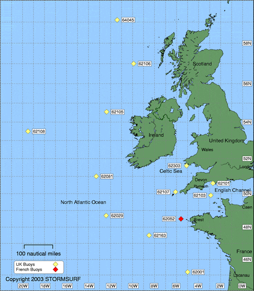
Stormsurf Buoys
(Click a buoy for detailed swell and surf data)
|
Buoys
(Arranged in sequence from north to south, east to west, offshore to nearshore)
Updated Hourly
Current Observations Swell Forecast Buoy Number Buoy Name Primary Observation Secondary Observation Spectral Density of Current Observation 6 hr Hindcast & 180 hr Forecast
(NOAA OMB)BRITISH ISLES
OffshoreTo view buoy locations select a Buoy Map: Buoy Map 64045 K5 Buoy NDBC Met Forecast 62106 RARH Buoy NDBC Met Forecast 62105 K4 Buoy NDBC Met Forecast 62108 K3 Buoy NDBC Met Forecast 62081 K2 Buoy NDBC Met Forecast 62029 K1 Buoy NDBC Met Forecast 62163 Brittany Buoy NDBC Met Forecast Nearshore 62303 Station Buoy NDBC Met 62305 Greenwich Lightship 62107 Seven Stones Buoy NDBC Met 62103 Channel Buoy NDBC Met
|
Surf Reports
| Location | Provider |
| Brighton | Sharkbait.co.uk |
| Cornwall & North Cornwall | Legm98 |
| Sennen Cove (Sevenstones) | Picture
and report sennen-cove.com |
| UK Surf Reports | Britsurf.org (UK Surf Index) |
Surf Forecast: Finisterre Surf Forecast (www.finisterreuk.com)
European Surf Information: http://www.beachwizard.com/
Current GOES-8 and METEOSAT Images
(Click on Image to Enlarge)
Courtesy: CIMSS NESDIS SSEC
| Current Images | Western Atlantic | Eastern Atlantic |
| Water Vapor |  |
 |
| Infrared |  |
 |
| Enhanced Infrared |  |
 |
METEOSAT Infrared Image with NOGAPS
Surface Pressure Overlay
Courtesy: NRL
Monterey
 |
Northern Hemisphere MRF Surface
Pressure and 500 mb Model
Courtesy: Purdue/UNISYS
 |
Surface Pressure From MRF Model
(Updated once daily at 00Z)
Image Courtesy: IGES/COLA
 |
| Alternate Surface Analysis Updated every 6 hours |
QuikSCAT Surface Winds
Courtesy: NOAA OPPT
(Descending Satellite Pass)
 |
Local Marine Wind Conditions
via QuikSCAT Satellite Based Wind Sensors
Courtesy: NOAA OPPT
(Descending Satellite Pass)
 |
North Atlantic NOAA Wave Model
Sea Height/Swell Vector/Period
(Uses Wavewatch III Model)
Courtesy: Scripps Research
Institute
| Height | Period |
 |
 |
North Atlantic 00hr NOAA Wavewatch
III Model
(Updated 2 times daily at 6Z and 18 Z)
Courtesy: NOAA OMB
| Height | Period |
 |
 |
Northeast Atlantic NOAA Wave Model
Sea Height/Swell Vector/Period
(Uses Wavewatch III Model)
Courtesy: Scripps Research
Institute
| Height | Period |
 |
 |
Winds at 850 mbs from MRF Model
(Updated once daily at 00Z)
Image Courtesy: IGES/COLA
 |
Stormsurf Buoy Forecasts
(Click a buoy for detailed swell and surf data)
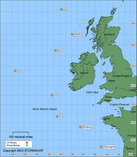
|
403
|
|||||||
|
|||||||
