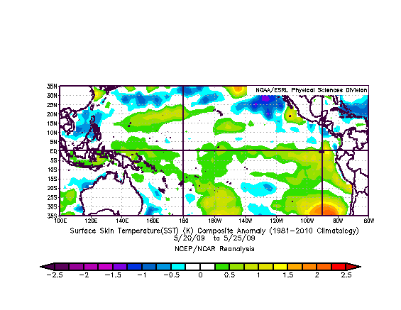
On 5/28 we performed a more detailed analysis of water term anomalies in the May 20 to May 25 timeframe comparing water temp anomalies of all other El Nino's from 1951 to present. The theory being the earlier the signature warm pool develops, the stronger it will become, because the more latent heat energy there is stored in the ocean. Surprisingly we actually found reanalysis date going back to 1951. One should view data prior to about '75 with much skepticism. We compared total areal coverage of warmer than normal waters on the equatorial Pacific and down the Ecuador and Peruvian coasts, and the coverage of warmers water in the direct vicinity of the Galapagos. Here's the results: the '97, '57 and '72 El Nino's beat the 2014 data, and ultimately ended up producing a 5 month running mean sea surface temp anomaly of +2.2, +1.8 and +1.6 degs C respectively. This 2014 event beat the next contending El Nino, the one of '65, which resulted in +1.6 degs anomalies. So from a statistical/historical perspective, this developing 2014 event should result in a SST anomaly of about +1.6 degs or the 4th strongest in the past 61 years. This is a theory that will be put to the test over the next 5 months. Data from the '82 El Nino is provided even though it had no contending footprint in the May timeframe because it ultimately resulted in SST anomalies of 2.0 degs above normal (5 month running mean). Also data from the '2009 El Nino is provided just because it was recent and likely still in most folks memories. So to have any warmer than normal water in the Nino 3.4 region in May (the Spring preceding when El Nino is declared) puts this 2014 event is an outlier category, presumably meaning some degree of a significant El Nino is developing. There is much variability between El Nino events, and not all are configured identical. That becomes apparent just inspecting the May '82 and '97 data. Two Super El Ninos, resulted, but with 2 different signatures early on. What's interesting is the configuration of this 2014 event is very similar to that of the 3 El Ninos ranked higher than it, all which produced significant results in the Fall and Winter months.
Strongest El Nino's
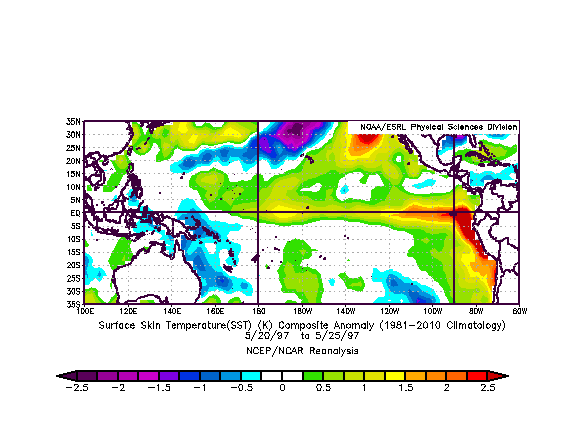
May 20-25 1997 SST Anomalies
(Greaterst ever - Ranked #1 for this time of year - +2.2 deg C final) |
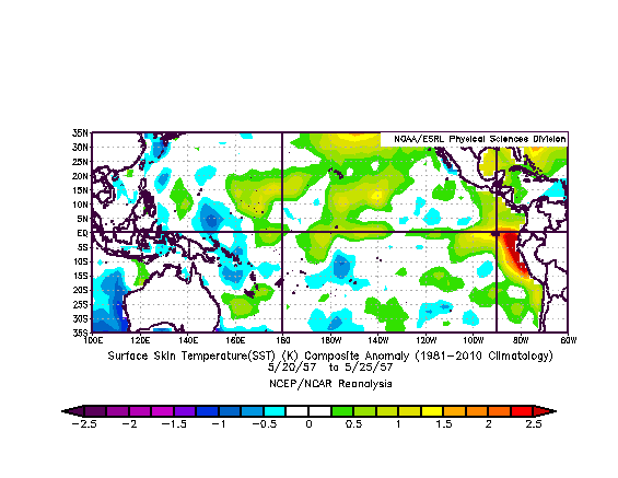
May 20-25 1957 SST Anomalies
(Greater than 2014 - Ranked #2 for this time of year - +1.8 deg C final) |
 |
 |
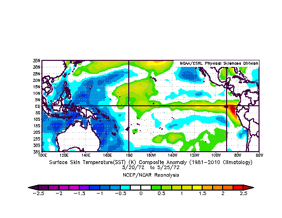
May 20-25 1972 SST Anomalies
(Greater than 2014 - Ranked #3 for this time of year - +1.6 deg C final) |
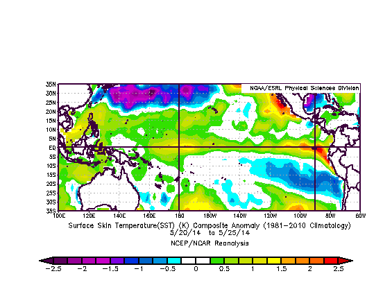
May 20-25 2014 SST Anomalies
(Ranked #4 for this time of year - ?? deg C final) |
 |
 |
Lesser El Ninos
(in May)
May 20-25 1965 SST Anomalies
(less than 2014 - Ranked #5 for this time of year - +1.6 deg C final) |
May 20-25 1982 SST Anomalies
(far less than 2014 for this time of year-+2.0 deg C final ) |
 |
 |
May 20-25 2009 SST Anomalies
(provided only for reference - Unranked - most recent El Nino - +1.4 deg C final ) |
|
 |
|
|
