Issued: 10/08/2001
Updated As Warranted
See ENSO page for Links and Current Data
ENSO Archives
WEAK EL NINO
CONDITIONS CONTINUE
NO Significant Change Expected
Weak El Nino conditions started developing in May 2001 and have continued, with a few breaks through September. Long-lead forecast models continue to forecast a shift to a stronger El Nino by May 2002.
Seasonally adjusted average Sea Surface Temperatures (SST's) across the equatorial Pacific Ocean for August and September have consistently indicated that warmer surface and sub-surface waters have been moving eastward. This is a major shift from the La Nina dominated pattern that prevailed for the previous 3 years, where all warm water was pooled up in the extreme western Pacific, driven there by abnormally strong trade winds (blowing east to west along the equator). In May 2001, a sudden shift in the pattern took.cgiace, with trade winds in the West Pacific turning calm, and even blowing towards the east. One particularly strong burst of easterly winds pushed a large surge of warmer water (known as a Kelvin wave) towards South America. That wave reached the South American coast in late July. Kelvin waves typically do not occur except during El Nino years. Eastward propagating Kelvin waves are driven by the Madden-Julian Oscillation (MJO), a cyclical weather pattern with duration of 30-60 days per cycle. It reaches it's peak during the transition from winter-to-summer and summer-to-winter. Since we are now entering that phase, this pattern could prove key to driving additional warm equatorial surface water eastward.
As of this report, average sea surface temperatures along the equatorial Pacific were about one half a degree (C) above normal from the far West Pacific eastward to just north of the Marquesas Islands (about 65% of the way across the Pacific 140W). A small imbedded pool of warmer water to 1 degree C was present in the far western Pacific. A very thin band of cooler than normal water was streaming westward off South America, driven by a small area of stronger than normal winds blowing west off South America, but this area was isolated and being held in-check. This pattern has been in.cgiace since May and no significant change is expected.
Average trade wind velocity along the equator in the West Pacific remained calm and are even blowing towards the east into early October. This again is in sharp contrast the pattern over the previous 3 years. Sea surface height, that is, the height of the seas surface relative to 'average' is slightly above normal as well, covering a thin band almost the entire way across the equatorial Pacific, ranging from 6-22 centimeters above average. Water that is higher than normal is also typically warmer than normal, so this measure further confirms the temperature pattern indicated above. The latest data indicates a stronger pattern than even 3 months ago.
Looking at the larger scale global picture, waters of the southern hemisphere are generally slightly cooler than normal, while the north hemisphere is warmer than normal. In the North Pacific, the warm water horseshoe pattern that has been in.cgiace for the past 3 years, the trademark of the latest La Nina pattern, is gone. Still, a large pool of much warmer than normal water continues to be evident extending from North Japan eastward into the northwest US. Imbedded within that pool is an area of water up to 3.5 degrees C above normal, centered on the dateline at 40N. Of interest, much cooler than normal water has taken up residence in the Gulf of Alaska and along the Aleutians Islands, probably the result of the early season storm pattern in that area, causing mixing of surface waters with the cooler deep water there.
Of great interest is what has been happening with the Southern Oscillation Index (SOI). The SOI compares relative barometric surface pressure between Darwin, Australia and Tahiti. A positive anomaly indicates La Nina while a negative anomaly indicates El Nino. It started indicating daily negative anomalies in mid-April and continued on that trend through May, and strongly so at times. The SOI index for the month of May averaged -9.9. This was the first time since the onset of La Nina in late '98 that any extended period of negative anomalies had been measured. A negative anomaly indicates that lower than normal average pressure is present over the Central Pacific while higher than normal pressure is in the far West Pacific. The negative SOI pattern retreated somewhat during June, with the average SOI up to +2.4. Then in July the trend returned negative, at -3.3 and -8.3 in August. September retreated somewhat to 1.7, but the first 8 days of October have all been negative (but one). Analysis of the MRF model to determine future surface pressures for Tahiti and Darwin indicates near normal pressure differences, indicative of a neutral SOI index. One would want to see a continuation of a negative SOI at some degree to say that an El Nino is in-progress.
A key indicator in the evolution of either an El Nino or La Nina event is the depth and profile of the 20 degree thermocline. During La Nina events, warm sub-surface water remains pooled up in the far West Pacific near the equator, with cold surface and subsurface waters dominating the East Pacific, resulting in a steep angle from east to west, going from shallow in the east to deep in the west. In El Nino events, warm subsurface equatorial waters migrate towards the eastern Pacific, reducing/flattening the angle. The most recent 20 degree thermocline profile indicates that large subsurface warm water pool that has been entrenched in the West Pacific for 3 years has made some significant progress eastward. A pocket of water up to 3 degrees C above normal has made it's way eastward. It was 100 meters under the dateline (180W) in July, and is now at 120W (due south of Southern CA) with a stream of water 1 degree C above normal streaming from it all the way back into the West Pacific. Changes in the sub-surface temperature profile do not occur quickly, especially considering the volume of water that must migrate eastward. The current pattern indicates a return to normal conditions or even slightly toward El Nino.
Outgoing Longwave Radiation (OLR) anomaly data (which measures cloud reflectivity/cloud cover) indicates near normal conditions across the Pacific, a definitive shift from previous years where dryer than normal conditions were prevalent in the East Pacific (over the colder waters) and wetter than normal conditions in the west (over the warmer waters that better support evaporation), typical of La Nina.
Of 8 ENSO models run in September, 5 are indicating neutral conditions through June of 2002, with 2 indicating warmer than normal conditions (El Nino) and 1 indicating colder conditions (La Nina). Sea-surface sea temperature forecasts from NOAA/NCEP indicate neutral conditions through the winter of 2001/2002, with significant warming of the tropical East Pacific starting in May 2002 and building into a full scale El Nino by July 2002. Seeing that the warm sub-surface migration is already in progress, and that the SOI has been consistently slightly negative, and that surface winds have remained light in the West Pacific, it seems probable that the forecast models are slightly out-of-sync with the weak El Nino that appears to already be occurring. Most analysts indicate that La Nina is dead and that a shift is in progress, with a solid El Nino event likely in 2002.
LONG RANGE NORTH PACIFIC STORM AND SWELL DEVELOPMENT FORECAST
Fall/Winter 2001/2002 Swell Potential Rating (for California) = 6.5
Forecasts data for the winter of 2001/2002 indicates that normal to slightly above normal water temperatures are expected for the equatorial Pacific, indicative of mild El Nino conditions. The continued presence of abnormally warm sea surface temperatures in the North Pacific (off Siberia extending to Washington state) will mostly likely remain in.cgiace as it has all year. The combination of normal to above-normal equatorial surface water temperatures and the warm North Pacific tongue should help to enhance the storm track from Siberia (North Japan/Kuril Islands/Kamchatka Peninsula) into the Gulf of Alaska. This should feed the winter storms moving along this path, permitting storms to be a bit stronger than normal and take a more southerly track as compared to past years. The additional strength should allow storms to travel further east of the dateline, unlike the winters of 1998 - 2000, where high pressure generally had a stronger grip on the Gulf region and forced many storms into the Aleutian Islands, obscuring their swell producing winds. The result of this enhanced storm track would be larger and more consistent swells, but the pattern could also bring stormier conditions to the western US coast.
(This forecast is highly speculative and based on historical analysis of past La Nina/El Nino events and the latest long-range forecast models)
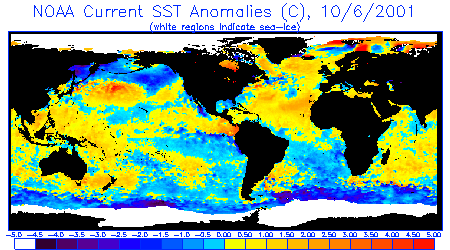
Sea Surface Temperature Anomalies
Courtesy: NOAA NESDIS
Notice that generally warmer waters are
covering the equatorial Pacific from the far west almost continuously eastward to Central
and South America, though a stream of cooler water continues to flow westward off South
America. A large area of warmer than normal water in the northern hemisphere extends
from Japan to the northwest US, with a strongly warmer pocket on the dateline.
Notice the cooler waters in the Gulf of Alaska and over the Aleutians.
 |
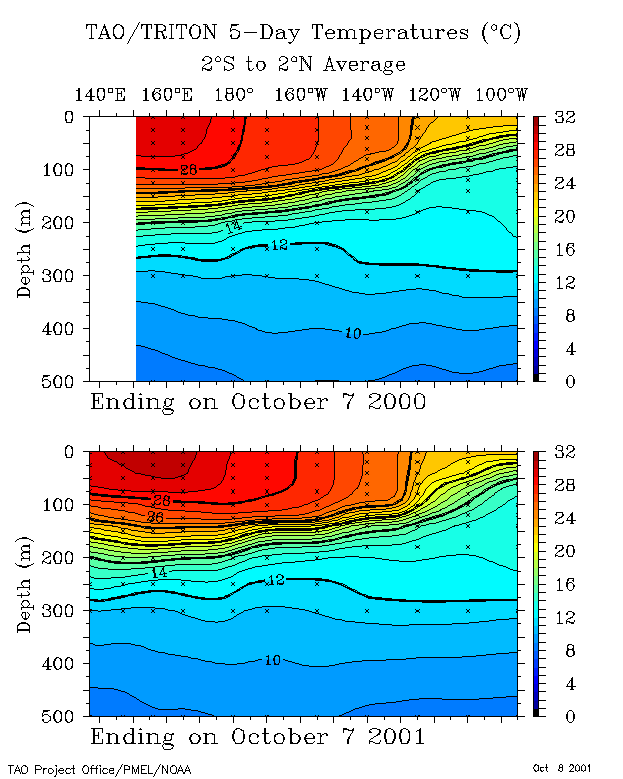
20 Degree Thermocline Depth and
Position Time Series
Courtesy: CPC NCEP NOAA
Warm sub-surface water is still entrenched in
the West Pacific, but has made significant eastward progress since last year and even over
the past 3 months.
 |
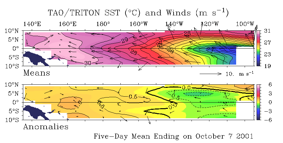
Sea Surface Temperature Anomalies
and Average Surface Winds on the Equatorial Pacific
Courtesy: NOAA PMEL
Notice warmer than normal SST conditions
currently ( +0.5-1.0 degrees C) cover much of the Pacific region from the far west to
about 140W. this is a slight loss from 3 months ago, but still a major gain compared to
last year. Also notice anomolously neutral winds over the equator in the Central
Pacific and that the trades have died in the far West Pacific, and have been r.cgiaced by
winds blowing towards the east.
 |
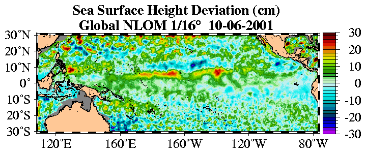
Sea Surface Height Deviation
Courtesy: NLOM
Notice that seas heights are higher than
normal in a thin band just north of the equator from the West Pacific to almost Central
America.
 |
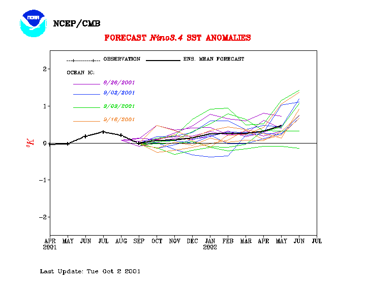
Equatorial Pacific Sea Surface
Temperature Forecast
Courtesy: NOAA/NCEP
Notice that 4 separate models runs (using
different starting conditions) indicate water temperatures over the Central Pacific are to
remain steady well into next year, then getting much warmer in May 2002.
 |
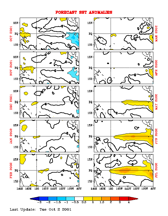
Equatorial Pacific Sea Surface Temp
Forecast
Courtesy: NCEP/CMB
Notice Sea Surface Temps are to remain generally
neutral through April 2002, then go strongly warm along the equator from May 2002 and
beyond.
 |
11125
Copyright © 2001 STORMSURF
This page cannot be duplicated, re-used or
framed in another window without express written permission.
|
||||||||
|
||||||||
