Mild El Nino Developing
Madden Julian Oscillation Strengthens
Starting with the winter of 2003/2004 a generally neutral trend was in.cgiace with occasional signals of a developing El Nino. That same trend continued well into the summer of 2004 but with the strength and frequency of the El Nino-like periods increasing, enough to potentially pass over the threshold to be considered a minimal El Nino by late August. Whether this evolves into a real El Nino for the winter season is still debatable, but it seems likely that the impact of these episodes on the overall North Pacific winter weather pattern should have a mildly positive influence on the storm generation potential.
Looking at current seasonally adjusted Sea Surface Temperatures (SST) across the equatorial Pacific, it is apparent that something is going on. Consistently warmer than average water temperatures have persisted on the equator near the dateline since last winter, though fluctuating in intensity and remaining just below the threshold to be considered noteworthy. But starting in July, and now into August, that trend has intensified and the pool of warm water is starting to move east towards Ecuador, typical of El Nino. Currently water temperatures of of 0.5 to 1.0° C above normal extend from just northeast of New Guinea eastward across the dateline and along the equator to due south of California, with the core of this warm pool 2° C above normal and positioned just north of the Marquesas Islands (140 W). This is reasonably solid and is obvious when examining the latest imagery. The standard summer-time cool tongue of water to -2° C is still present extending westward off Ecuador, but has slowly been receding, loosing ground to the momentum of the warmer waters encroaching upon it from the west. Elsewhere in the Pacific warmer than normal waters continue to be across the entire North Pacific, terminating in a large pool positioned along the US west coast, similar to last winter and into 2004 and are likely present due to last winters occasional bursts of El Nino like conditions. Warmer than normal waters are also present in the tropical East Pacific. Most of the South Pacific remains in the normal range with only a small pocket of slightly warm water east of New Zealand.
QuikSCAT imagery and wind anomaly analysis indicates that the normal trade winds in the far West Pacific have reversed direction, now blowing from west to east and covering from south of the Philippines to south of the Marshall Islands (just west of the dateline). This is a significant trend and is likely attributable to the current strong phase of the Madden Julian Oscillation (MJO - more details below). Trades are suppressed, but have not reversed direction, from the dateline eastward to about 160W, a bit short of the core of the warm water pool discussed above. During a typical El Nino this time of year one would expect to see slack to no trades with bursts of westerly winds from the Philippines eastward to nearly 120W. We appear to be rapidly approaching such conditions. Conversely, if La Nina was in-effect, the trades would be blowing hard east to west across the entire equatorial Pacific, which is clearly not the case. In all, winds look definitely El Nino like for the time of year.
Another indicator of El Nino or La Nina is a change in sea surface height. Seas surface height is the height of the oceans surface relative to 'average'. As indicated by satellite analysis a moderate band of waters running about 10-15 centimeters higher than normal spans the width of the equatorial Pacific from just west of the dateline eastward to the Galapagos Islands. This is somewhat above normal, but not markedly so. Of note though is that these higher waters are more pronounced than last year, presumably indicative of the potentially developing phase of a weak El Nino.
The 30 and 90 day average Southern Oscillation Index (SOI) are not strongly indicating El Nino. This is the one indicator that gives us some pause. This index compares barometric surface pressure between Darwin, Australia and Tahiti. A negative anomaly (signaling El Nino) indicates that lower than normal surface pressure is present over the Central Pacific while higher than normal pressure is in the West Pacific. A positive SOI (La Nina) means the pressure pattern is reversed. During April 2004 the 30 day trend was very negative, indicating El Nino, but returned to normal in early May and even trending towards La Nina. Then again in June the trend went even stronger to the negative only to return to a near neutral state late in the month. And then again in July to trend dipped well into the negative range, only to rebound some in early August, but not giving up the slight negative tendency. These steep dips are associated with an increase in the Madden Julian Oscillation (MJO) over the West Pacific during the noted time-frames (more details below). The 90 day trend, which attempts to average out the sporadic peaks and valleys in the curve now suggests a slight tendency towards El Nino, but nothing that stands out. Still, this tendency could be the start of a pattern, but it's just too early to tell with any certainty.
Another key indicator in the evolution of either an El Nino or La Nina event is the depth and profile of the 20 degree thermocline. During La Nina events, warm subsurface water remains pooled up in the far West Pacific near the equator. Cold surface and subsurface waters dominate the East Pacific, resulting in a steep angle from east to west, going from shallow in the east to deep in the west. In El Nino events, as warm subsurface water (i.e. Kelvin waves) migrate towards the eastern Pacific, the angle flattens and becomes more consistent across the equatorial Pacific. Latest data indicates that the thermocline is definitely more flat than last year, which itself had tendencies towards El Nino, suggesting a stronger trend is in.cgiace this year. Of note is the repositioning of the core of the central warm pool, now over the dateline rather than at 160E. This is another hint of a developing trend towards El Nino, but not strongly so.
Of real interest is the clear indication of Kelvin Wave activity. A Kelvin Wave is a pocket of warm water that travels under the oceans surface from west to east at a depth of about 150-200 meters. It is generated by a burst strong westerly winds blowing over the equator in the West Pacific associated with the MJO. As the warm water gains eastward momentum, it sinks and travels well under the oceans surface, only to reappear at the surface when it impacts the South America Coast. This results in the sudden appearance of warm waters along the coast of Peru and Ecuador. Occasional eruptions are normal. Large and consistent eruptions are the hallmark of solid El Nino events. The source of Kelvin Waves, a negative SOI and reversed trades is directly related to the strength and frequency of the Madden Julian Oscillation (MJO). This weather pattern is responsible for the periodic strengthening of the anomalous westerly winds in the West Pacific which drive production of subsurface Kelvin waves, and also drive the SOI negative. When the MJO enters an active phase, El Nino indicators strengthen, and as it fades, so does El Nino. At this time there is clearly a Kelvin Wave with temperature 4.0° C above normal positioned 75 meters under the oceans surface on the equator at 120W, approaching the South American coast and expected to impact it in late August. If El Nino were developing, we would want to see more of these events developing. At this time no other Kelvin Waves appear to be in production, but the season is still early and previous manifestations of the MJO this year have produced smaller Kelvin waves, so it would be reasonable to expect more to appear as we move deeper into the season.
Reviewing all the evidence, there are some decent indications of a developing weak El Nino. Trade winds are reversed in the West Pacific, Sea surface temperatures are marginally above normal in the area typically associated with El Nino as are sea surface heights. There is a solid Kelvin Wave en route to the South American coast, the strongest of several that have made the journey so far this year. The SOI has been periodically negative, very much so at times, and is showing no signs of moving into the positive range. Of interest is the seasonal hurricane forecasts produced by Dr. William Gray and the team at the University of Colorado. Their April 2nd forecast suggested that mild La Nina conditions were expected in the Eastern Pacific through the summer based on trends at key locations in all oceans over the previous 6 months. This also contributed to their assessment that, like most years in the recent past, enhanced tropical storm activity was expected for the the Atlantic hurricane season (northern hemisphere summer). But the latest update published August 6 reverses direction somewhat and now suggests that strengthening El Nino signals in the Pacific will have a negative impact on the development of tropical systems in the Atlantic, and they have therefore adjusted their forecast downward. Also of interest is the latest El Nino discussion from the Climate Prediction Center/NCEP. Their assessment suggests that there is a 50% probability that the threshold for minimal El Nino criteria will be met by the end of the month (August). This data further substantiates that some form of El Nino activity appears to be underway. The big wild card in all the analyses is the MJO. If it continues to be active, the meteorological signals that are driving El Nino symptoms will likely continue to be manifest. If the MJO falters, a normal year will result. It is too early to tell with any certainty, especially since only the latest MJO is driving most of the El Nino forecasts. Another 30-45 days of observation is required before a definitive forecast can be made, but the trend is towards El Nino at this time.
Of 11 ENSO models run in July, about half indicate neutral conditions while the other half indicate mild El Nino. None indicate La Nina. Given that we are starting to enter the prime El Nino development window, and the over-all meteorological pattern is towards El Nino, it seems reasonable that a weak El Nino pattern will persist and we have factored this into our most current swell potential rating.
LONG-RANGE NORTH PACIFIC STORM AND SWELL GENERATION POTENTIAL FORECAST
Fall-Winter 2004 Swell Generation Potential (for California & Hawaii) = 6.5
There is no data supporting development of a significant El Nino event this year, but lot's of data suggesting a mild one. In actuality, if a mild one develops, this would be good. It is not uncommon to have a series of years where mild El Nino conditions persist. They slowly and subtly change the atmospheric weather patterns in favor of producing slightly stronger and more frequent winter storms in the North Pacific, but not so much as to cause full blown storm conditions to fill the North Pacific basin. During strong El Nino events, storm conditions often take over the coastal regions of Hawaii and the US West Coast, making the large waves produced by these strong winter storms unrideable from a surfing perspective and inflicting needless damage to property and civilian livelihood. The spectacle produced by such events is certainly not worth the cost to humans and wildlife. But the subtle guiding influence of a mild El Nino strung out over several years can produce a series of climatic changes that favor the development of storms in both the North and South Pacific without the associated poor local weather and damaging winds and rains. We are hopeful that such a pattern is developing.
All current predictive data continues to suggest we are approaching development of a mild El Nino pattern in the coming few months. But for the short-term (through September), no significant change in the storm and surf pattern is forecast. But if El Nino does develop, it would be likely for late season West Pacific typhoons to recurve to the northeast and become extratropical, possibly moving towards the dateline and eventually the Gulf of Alaska. Given that this current El Nino is rather weak and late in developing, the extratropical influence is not expected to be strong and possibly even un-noticeable. Likewise as the late Fall and early Winter seasons occurs, a slow but steady enhancement to the normal storm track could be expected, with some increase in the size and consistency of the winter surf pattern occurring, and certainly better than the past 2 years. The El Nino enhancement could also have the ability to extend the winter surf season a month or so longer than normal, but not strongly.
So for now,.cgian on a 'normal' summer (though it's been something less than that in July going into August) and a normal start to the early Fall season. A slow evolution towards a mildly more active pattern could then develop, but it's still too early to tell with any certainty.
(This forecast is highly speculative and based on historical analysis of past La Nina/El Nino events and the latest long-range forecast models)
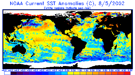
Sea Surface Temperature Anomalies
Courtesy: NOAA NESDIS
Notice a small thin tongue of cooler than normal water (dark blue) extending west from Ecuador, created by upwelling from easterly winds off the land there. But of more interest is the area of warmer than normal water (orange) over the Pacific equator extending east from the dateline to the Marquesas Islands, a sign of El Nino. Also notice warmer than normal waters extending across the entire North Pacific and pushing into the Gulf of Alaska.
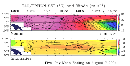
Sea Surface Temperature Anomalies and Average Surface Winds on the Equatorial Pacific
Courtesy: NOAA PMEL
In the top image notice winds actually blowing from west to east, against the normal trade wind flow in the far West Pacific. Notice in the lower image the pool of warmer than normal water in the mid-equatorial Pacific with near neutral winds over it. The water temp pattern is being driven by the surface winds over it.
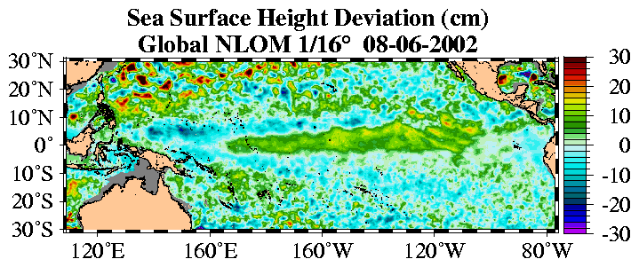
Sea Surface Height Deviation
Courtesy: NLOM
Like the images above, notice that sea surface heights are slightly above normal right over the equator and over the same area where the seas are warmer (as would be expected).
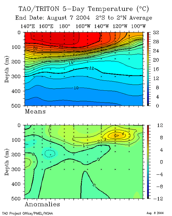
20 Degree Thermocline Depth and Position Time Series
Courtesy: CPC NCEP NOAA
(Top Image) A core of warm subsurface water is centered in the West Pacific but has moved eastward since the last report, indicative of a potentially mild El Nino.
(Lower Image) Notice a pocket of anomalously warm water (4° C) at 125W and at about 80 meters deep. This is a Kelvin Wave produced a month ago by strong westerly winds in the West Pacific by a pulse of the MJO.
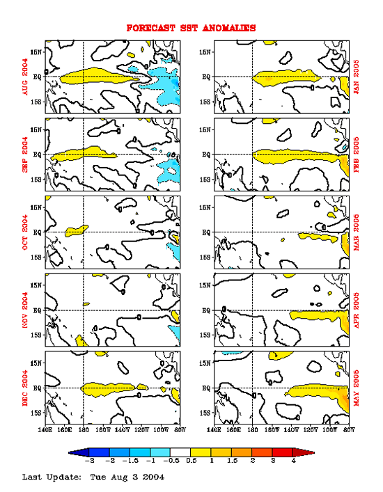
Equatorial Pacific Sea Surface Temperature Forecast
Courtesy: NOAA/NCEP
Notice that 4 separate runs of the NCEP model (started at 4 separate times) suggests a continuation of a mild warm trend through the winter of 2004/2005. This is consistent with 50% of the available ENSO modeling tools/suites.
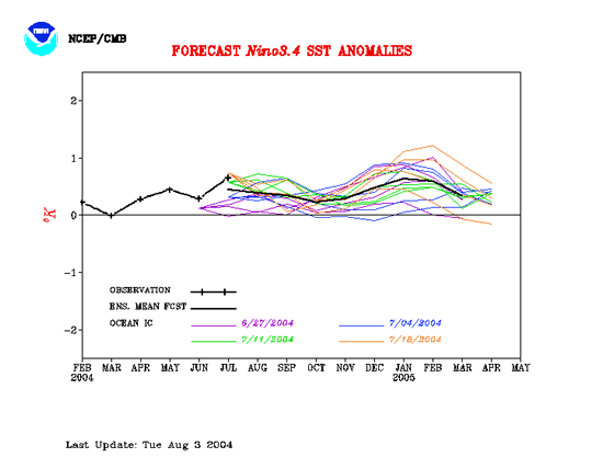
Equatorial Pacific Sea Surface Temp Forecast
Courtesy: NCEP/CMB
NCEP Model: Notice Sea Surface Temps are to remain mildly warm well into the Spring of 2005, typical of a weak El Nino.
|