Issued: 06/10/2002
Updated As Warranted
See ENSO page for Links and Current Data
ENSO Archives
EL NINO CONDITIONS
CONTINUE EVOLVING
Stronger Signals Occurred in May
Since March 2001 we have witnessed the Tropical Pacific Ocean change from being dominated by La Nina towards an El Nino configuration. That trend continued to strengthen in March and April 2002, with pronounced changes occurring in May 2002. A mild to moderate El Nino seems likely for the Fall and Winter of 2002/2003.
Seasonally adjusted Sea Surface Temperatures (SST) across the equatorial Pacific Ocean since August 2001 have consistently indicated that a slow but steady warm-up is in progress. April 2002 saw a halt in that trend, with no additional warming occurring, but not giving away much either. Then in May through release of this report, a significant strengthening was underway. Sea surface temperatures along the equator were at least 0.5 degree C above normal from well west of the dateline the whole way east to the South American coast, with most of that area at least 1 degree C above normal, and a small imbedded area to 1.5 degrees above normal centered near 160W.
Average trade wind velocity along the equator in the West Pacific still remains weaker than normal, typical of El Nino. Calm winds are occurring over the west Pacific and wind anomalies even blowing towards the east into the Central Pacific. This is again in sharp contrast to the pattern of the previous 3 years. Sea surface height, that is, the height of the oceans surface relative to 'average' is above normal as well, with a well defined band of ocean heights 6-10 cm above normal extending the entire way across the equatorial Pacific and up to 16 cm between 120-160W. Water that is higher than normal is also typically warmer than normal, so this measure helps to further confirm the temperature pattern indicated above. The latest data indicates the pattern is stronger and better defined than at the last report (in March 2002).
Looking at the larger scale global picture, waters of the southern hemisphere are cooling down, especially east of New Zealand, while the north hemisphere appears to be warming up. The Pacific warm water 'horseshoe' pattern that was so prevalent during the La Nina years is gone. This pattern was evidenced by a large area of warmer than normal water extending from Japan northeastward to just north of Hawaii and southeast from North Australia to nearly Chile. A cooler than normal water is now isolated to an area that covers the US west coast and westward about 1000 nmiles. This is being generated by strong upwelling caused by a persistent high pressure pattern locked off the Northern CA coast.
The biggest change over the past 3 month has been in the Southern Oscillation Index (SOI). It is a measure that compares relative barometric surface pressure between Darwin, Australia and Tahiti. A negative anomaly (signaling El Nino) indicates that lower than normal average pressure is present over the Central Pacific while higher than normal pressure is in West Pacific. A positive SOI (La Nina) means the pressure pattern is reversed. Since March of 2001 the SOI has teetered back and forth between mildly positive and mildly negative (-10 to +10 monthly) and had not yielded evidence to suggest either El Nino or La Nina, but rather towards a neutral pattern. One wants to see a continued negative SOI to say that an El Nino is in-progress. That appeared to be the case starting in March 2002 when the SOI went mildly negative and has only strengthened since then. The readings for May 2002 were at -15.3, the most negative it has been since April 1998, the end of the biggest El Nino on record. It appears that the warm SST pattern has been in.cgiace long enough and with enough intensity to start modifying the atmospheric pattern above it.
On June 6 the SOI returned to near 0/neutral readings through report time, and forecast models suggest it should remain that way for at least the next week. It is too early to tell if it will return to it's negative trend.
Another key indicator in the evolution of either an El Nino or La Nina event is the depth and profile of the 20 degree thermocline. During La Nina events, warm subsurface water remains pooled up in the far West Pacific near the equator, with cold surface and subsurface waters dominating the East Pacific, resulting in a steep angle from east to west, going from shallow in the east to deep in the west. In El Nino events, as warm subsurface water (i.e. Kelvin waves) migrate towards the eastern Pacific, the angle flattens and becomes more consistent across the equatorial Pacific. The latest data indicates that the thermocline angle has flattened considerably, with what appears to be another Kelvin wave progressing eastward, positioned 50 meters below the oceans surface just off the South America coast with a temperature at 3-4 degrees C above normal. We have been monitoring this ones progress across the Pacific. This strongly points toward El Nino.
Of 11 ENSO models run in May 2002, 8 are indicating warm conditions becoming dominant between May and November 2002. Sea-surface temperature forecasts from NOAA/NCEP indicate generally neutral conditions through October, with significant warming of the tropical East Pacific building into a moderate El Nino by January 2003. Seeing that the warm surface and sub-surface migration is already in progress, that atmospheric precipitation near the dateline is enhanced, and that surface winds remain light in the West Pacific, it seems probable this forecast model is out-of-sync with the weak El Nino that appears to already be occurring.
The seasonal change known as the Spring Barrier (March and April) has passed, and the risk with predicting an El Nino before the passage of this barrier has diminished. The forecast for the rest of the year should become more stable. Considerable month-to-month variation in the various measures seem likely, but the overall trend is expected to continue toward the evolution of El Nino by the Fall. Monitor this situation closely.
LONG RANGE NORTH PACIFIC STORM AND SWELL DEVELOPMENT FORECAST
Summer/Fall 2002 Swell Potential Rating (for California) = 4.5/7.0
Forecast data for the summer and fall of 2002 indicates that normal to slightly above normal water temperatures are expected for the equatorial Pacific, indicative of developing El Nino conditions. Short-term anomalously high pressure has again set-up east off Australia and is negatively impacting the winter (southern hemisphere) storm pattern there. This will serve to dampen swell generation potential in the south hemisphere which will not bode well for surf conditions along the coasts of California and Hawaiian during the summer months. But the potentially building presence of El Nino should serve to a.cgiify the development of tropical systems off Central America throughout the season and re-direct late season typhoons off Japan towards the open waters south of the Aleutians, enhancing the probability for extra-tropical storm development (more-so than it did in late summer 2001). The presence of warmer than normal water in the North Pacific will likely remain in.cgiace, which could have some enhancing impact on storm generation potential there as we move into the fall and winter months. In all, the prognosis for summer storm development (in the South Pacific) is to be below normal, with increased storm potential developing as we move into the fall and winter.
(This forecast is highly speculative and based on historical analysis of past La Nina/El Nino events and the latest long-range forecast models)
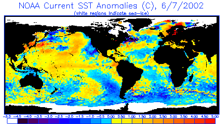
Sea Surface Temperature Anomalies
Courtesy: NOAA NESDIS
Notice a darker current of warm water that now extends along the equator from New Guinea
nearly straight eastward to Ecuador, then branching south along the Peruvian coast into
Chile and northward to Baja Mexico. Warm water also is covering much of the North Pacific
while fading in the South Pacific. Cooler waters remain off the US west coast.
 |
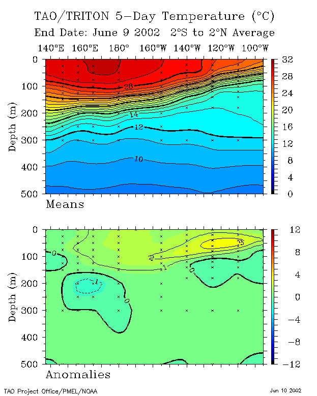
20 Degree Thermocline Depth and
Position Time Series
Courtesy: CPC NCEP NOAA
(Top Image) Over the past year the core of warm sub-surface water that dominated the West
Pacific continues to make solid progress east and is increasing it's depth there. Notice
the wall of warm water at 28 degrees centered at 130W. This is pushing eastward. (Lower
Image) Notice the pocket of anomalously warm water at 3 degrees above normal pushing
eastward (a Kelvin Wave), nearly ready to impact the South America coast. It is a bit
curious that no other pockets of warm water are building behind it though.
 |
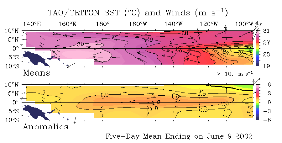
Sea Surface Temperature Anomalies
and Average Surface Winds on the Equatorial Pacific
Courtesy: NOAA PMEL
Notice warmer than normal SST conditions currently (+1.0 degrees C) cover almost the
entire equatorial Pacific. A core a warm water to 1.5 C is imbedded at about 150W.
Also notice anomalously neutral winds and even some blowing east over almost the entire
length of the equator.
 |
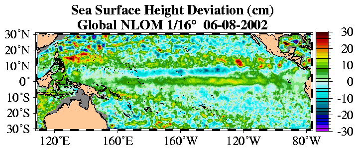
Sea Surface Height Deviation
Courtesy: NLOM
Notice that seas heights are higher than normal almost continuously along the equator from
west to east, with a secondary band to it's north at about 10N.
 |
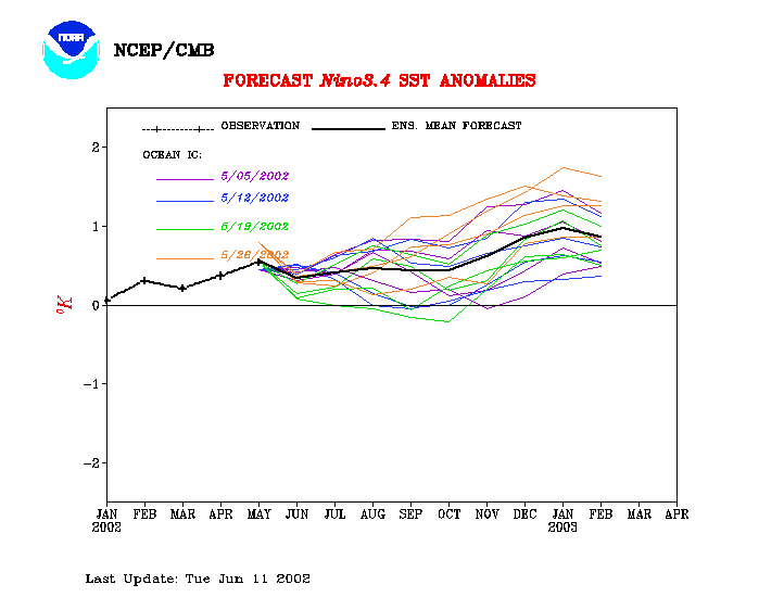
Equatorial Pacific Sea Surface
Temperature Forecast
Courtesy: NOAA/NCEP
Notice that 4 separate runs of the model (started at different times) indicate water
temperatures over the Central Pacific are to slowly increase through the winter of
2002/2003.
 |
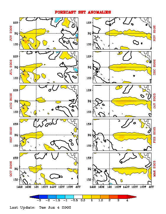
Equatorial Pacific Sea Surface Temp
Forecast
Courtesy: NCEP/CMB
NCEP Model: Notice Sea Surface Temps are to remain generally neutral through October 2002,
then go warmer along the equator through May 2003.
 |
10841
|
||||||||
|
||||||||
