Issued:
4/4/2003
Updated
as Warranted
See
ENSO page for Links and Current Data
ENSO Archives
EL NINO Fades
Neutral Conditions
Forecast
The peak of the latest El Nino episode occurred in November of 2002, and a slow but steady degradation of it's signals occurred through the spring of 2003. Some lingering affects remain, but are expected to subside to near neutral by summer.
Seasonally adjusted Sea Surface Temperatures (SST) across the equatorial Pacific are still running about 0.5-1.0 degrees C above normal, with the core of warmest water positioned over the dateline. During El Ninos peak, the core of the warm pool had water temperatures 3.5 to nearly 4.0 degrees above normal positioned near 160W. Now that pool of warmer water is slowly loosing it's edge though it continues to cover a respectable area, from Costa Rica westward to the Marshall Islands and beyond. But in general, most of these waters are only 0.5 degree above normal or less, not particularly impressive. And when viewed in conjunction with previous months imagery, it clearly indicates a regressive pattern as the warm water fades and shrinks in areal coverage. A small and persistent pool of cooler than normal water has developed off Peru and is flowing west to and past the Galapagos Islands, which is not unusual for this time of year. This is the result of normal upwhelling caused by winds blowing from Peru westward, pushing away warm surface waters and allowing the cool nutrient rich waters of the deep Pacific to rise to the surface off the South American coast. It would be expected that this area of cool waters will continue to expand in size westward through the coming months as the warm water recedes. Cooler than normal temperatures prevail off the Philippines and the West Pacific northeast to Japan, the Kuril Islands and the Kamchatka Peninsula, then eastward across the dateline and into the western Gulf of Alaska. Warmer than normal water temperature prevail along the coast of Baja Mexico northwestward up the US west coast into Canada and the Gulf of Alaska, typical springtime conditions after an El Nino. No clear or obvious trend is present in the South Pacific, with neutral conditions in control there.
QuikSCAT imagery and wind anomaly analysis indicates trade winds along the equator in the West and Central Pacific are near normal, neither blowing harder or weaker than normal. QuikSCAT imagery indicates an average speed near 15 kts to the west. During El Nino events winds here are typical calm or even blow from the west to the east in the presence of the Madden Julian Oscillation (MJO), which is not the case now.
But the real indicator of the change in pattern is sea surface height measurements. Seas surface height, that is, the height of the oceans surface relative to 'average' has sunk to normal levels over a thin but cutting edge that extends from Columbia and Peru westward across the entire equatorial Pacific the whole way to the Philippine Islands. There is virtually no indication of any abnormality across the entire Pacific, suggesting that surface winds are back to normal and the machine that drives warm waters eastward has shut off completely. Higher than normal water heights typically represent the presence of warmer than normal waters, and lower than normal heights represent cooler than normal water. This data is likely a leading indicator of what will happen to water temperatures in the months to come and supports the assessment that El Nino is dead.
The 30 and 90 day average Southern Oscillation Index (SOI) continues to remain slightly negative, as it has since early this year. This index compares barometric surface pressure between Darwin, Australia and Tahiti. A negative anomaly (signaling El Nino) indicates that lower than normal surface pressure is present over the Central Pacific while higher than normal pressure is in the West Pacific. A positive SOI (La Nina) means the pressure pattern is reversed. On a daily and weekly basis, the trend has been swinging mildly back and forth between negative and positive, with sporadic events more on the negative side than positive. This is likely an indication that though surface winds have reversed to a neutral direction, the upper levels of the atmosphere have yet to fully realize that El Nino is fading, and continue to produce storm and weather pattern typical of El Nino. This is normal and one would expect the SOI to slowly return to a neutral condition over the next several months as the atmosphere looses it's El Nino bias. Post El Nino, the SOI is more of a lagging indicator that a leading indicator (like it is during the onset of El Nino).
Another key indicator in the evolution of either an El Nino or La Nina event is the depth and profile of the 20 degree thermocline. During La Nina events, warm subsurface water remains pooled up in the far West Pacific near the equator. Cold surface and subsurface waters dominate the East Pacific, resulting in a steep angle from east to west, going from shallow in the east to deep in the west. In El Nino events, as warm subsurface water (i.e. Kelvin waves) migrate towards the eastern Pacific, the angle flattens and becomes more consistent across the equatorial Pacific. Latest data indicates that there is absolutely no warm sub-surface water present across the entire length of the equator, and if anything, a cool anomaly has established itself at the key depths between 100-200 meters down. Current measurements indicate temperatures of 1-2 degree below normal.
The hallmark of developing El Ninos is the strength of the Madden Julian Oscillation (MJO). This weather pattern is responsible for the periodic strengthening of the anomalous westerly winds in the West Pacific which drive production of subsurface Kelvin waves, and also drive the SOI negative. When the MJO enters an active phase, El Nino indicators strengthen, and as it fades, so does El Nino. At this time there is no evidence of any Kelvin waves or MJO activity in the Pacific.
It appears that trade winds and sea surface heights are coming back to normal levels. The SOI index and the presence of warm surface waters are still registering shadows of last winters El Nino, but in both cases, the trend is turning back towards a normal pattern. The upper level weather pattern in the North Pacific continue to show the influence of El Nino, but not strongly, consistent with a fading moderate El Nino. It will be interesting to watch the Atlantic hurricane pattern this year to see how it develops. Suspect it will be stronger than last year.
Of 11 ENSO models run in March 2003, 8 indicate neutral conditions becoming dominant by August 2003. This is considered normal from a historical perspective in that the physical processes that cause El Nino to develop start breaking down in the late summer. This is consistent with what we are observing too in regards to the SOI and trades. Two models suggest a return of El Nino, with one indicating La Nina. Sea-surface temperature forecasts from NOAA/NCEP indicate neutral equatorial water conditions through October 2003, with a small warm pool developing in November and December, then fading. Basically one step short of neutral.
LONG-RANGE NORTH PACIFIC STORM AND SWELL GENERATION POTENTIAL FORECAST
Summer/Fall
2003 Swell Generation Potential (for California & Hawaii) = 3.5/5.0
(Scale
is from 1-10 with a 1 equaling low potential and a 10 equal to high potential)
There is no indication that El Nino will somehow make a miraculous and sudden comeback, and it seems all but certain we're heading towards a neutral phase. There is not a strong correlation between El Nino and the southern hemisphere winter storm pattern, but last years data suggests that this most recent El Nino might have had a suppressive affect on storms there. Using that at a short-lead indicator, we suspect that the lingering affects of El Nino in the upper levels of the atmosphere will continue to suppress winter storm development there (under Australia migrating through the Tasmanian storm corridor into the South Pacific). This could result in fewer and smaller summer swells migrating northeast towards California and Hawaii. Further out, with the complete dissipation of El Nino, it is possible the storm pattern could reestablish itself to normal levels by mid-to-late summer, but that's just a guess.
In the tropical east Pacific, neutral conditions will likely not help to enhance hurricanes moving west off Central America. Expect the standard number and strength of storms in that location. From a late season typhoon perspective, neutral conditions will likely have neither a positive or negative affect on directing typhoons from the West Pacific towards the open waters south of the Aleutians and towards the Gulf of Alaska.
In short, expect slightly less than normal summer swell activity from April to June, with a return to normal by July into September.
(This forecast is highly speculative and based on historical analysis of past La Nina/El Nino events and the latest long-range forecast models)
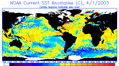
Sea Surface Temperature Anomalies
Courtesy: NOAA NESDIS
Notice a weak but broad area area of warmer than normal surface water temperatures
(yellow) that extend from Central America westward to nearly the Philippines.
But also notice the cooler than normal waters (dark blue) trickling west from
Peru to the Galapagos Islands and beyond. Also notice warmer than normal waters
off the US west coast and Canada, after affects of this winters El Nino.
 |
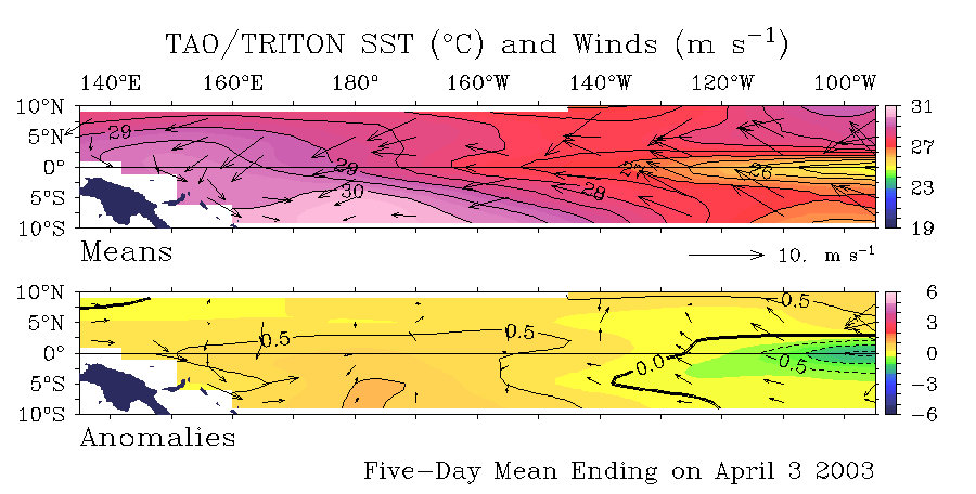
Sea Surface Temperature
Anomalies and Average Surface Winds on the Equatorial Pacific
Courtesy:
NOAA PMEL
Notice slightly warmer SST conditions currently (+0.5 degrees C) cover the balance
of the equatorial Pacific from 140E to 120W. But more interesting, notice a
tongue of cold water and winds blowing from east to west off Peru. It's too
early to know whether this area will persist or die, but it worth monitoring.
 |
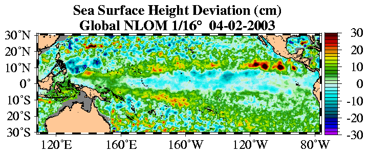
Sea Surface Height Deviation
Courtesy:
NLOM
Of real interest, notice that seas heights are normal almost continuously along
the equator from 160E to South America. This is a dramatic return to normal
condition that has evolved over just the past 3 months.
 |
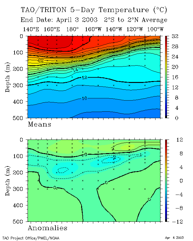
20 Degree Thermocline Depth
and Position Time Series
Courtesy:
CPC NCEP NOAA
(Top Image) A core of warm subsurface water that dominated the central Pacific
is beginning to migrate back west, typical of neutral conditions.
(Lower Image) Notice the pocket of anomalously cool water at 1-2 degrees below
normal covering the entire width of the Pacific at a depth of 100-200 meters.
 |
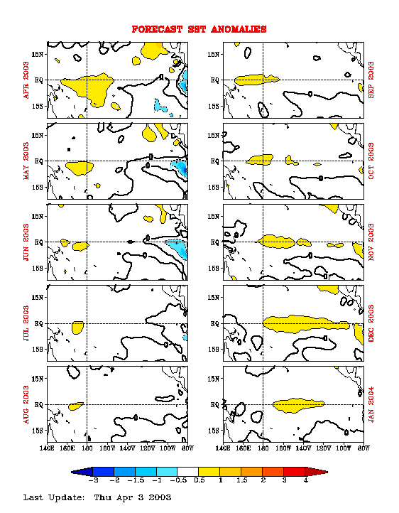
Equatorial Pacific Sea Surface
Temperature Forecast
Courtesy:
NOAA/NCEP
Notice that 4 separate runs of the model (started at different times) indicate
water temperatures over the Central Pacific are to remain at or slightly above
normal through the winter of 2004. Bu the margin of warmness (.25 degree) is
so small that it should be considered neutral. At least it's better than being
negative.
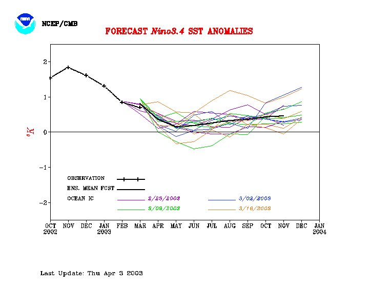 |
Equatorial Pacific Sea Surface Temp
Forecast
Courtesy: NCEP/CMB
NCEP Model: Notice Sea Surface Temps are to remain basically neutral through
January 2004.
 |
735
|
||||||||
|
||||||||
