EL NINO SOUTHERN OSCILLATION (ENSO) FORECAST
Updated As Warranted
![]()
EL NINO SOUTHERN OSCILLATION (ENSO) FORECAST
Updated As Warranted
Issued: 11/12/99
See ENSO page for Links and Current Data. ENSO Tutorial
MODERATE LA NINA
IN-CONTROL
But El Nino Conditions Still
On-Track for 2000
La Nina continues to control the global weather pattern as has been predicted by most major sea surface temperature models, and should continue to be a dominate factor affecting both the Pacific and Atlantic weather patterns through this winter. But a shift continues to be forecast for next spring.
Sea Surface Temperatures (SST's) across the equatorial eastern and central Pacific are solidly below normal by about 1.0 to 1.5 degrees (C) in a large area spanning the entire equatorial Pacific Ocean. The trades are blowing at a moderate rate from east to west, enough to continue the pattern of cold upwelling in the east Pacific. This wind pattern is pushing warmer waters towards the Asian continent. Locally along the Canadian and US west coast, trades are keeping ocean temperatures well below normal. The depth of the 20 degree thermocline remains greater than normal in the western Pacific and shallower than normal in the eastern Pacific, again indicating colder than normal surface waters in the East Pacific and warmer than normal surface temperatures in the West Pacific, typical of La Nina events. There is no evidence that a change in the thermocline depth is occurring either.
Outgoing Longwave Radiation (OLR) anomaly data which measures cloud reflectivity/cloud cover, indicates dryer than normal conditions in the East Pacific (over the colder waters) and wetter than normal conditions in the west (over the warmer waters that better support evaporation), again indicative of La Nina.
The Southern Oscillation Index (SOI) which is used to compare relative barometric surface pressure between Darwin Australia and Tahiti continues to be solidly positive, indicating that high pressure still generally dominates the East and Central Pacific while lower than normal pressure dominates the West Pacific, again typical of La Nina.
La Nina was a major factor in dampening the East Pacific hurricane season. Colder than normal ocean conditions just off Central America made for a rather limited area than could support tropical storm development in the eastern Pacific. Moderate to strong La Nina conditions in the winter months have historically negatively impacted the North Pacific swell production pattern. Conversely, La Nina had a positive impact on the Atlantic Ocean hurricane season.
LONG RANGE STORM AND SWELL DEVELOPMENT FORECAST
Fall/Winter 1999/2000 Swell Potential Rating = 3.5
The probability for storm and swell development in the Pacific Ocean for the remainder of 1999 and into early 2000 remains lower than normal. On a 1-10 scale, the potential for storm and swell development in the Pacific Ocean for the fall and winter of 1999/2000 remains weak, rating about a 3.5 (10 being high probability for large swells and 1 being a low probability for large swells). But as like the winter of '98/'99, the presence of abnormally warm sea surface water in the NW Pacific (off Siberia to nearly the Gulf of Alaska) could have a positive affect on storm development, which is still not fully understood.
Of interest though is the the sea surface temperature forecast from NOAA/NCEP. Over the past months forecasts have continually indicated a significantly change in the pattern for the Spring of 2000. A shift towards neutral to El Nino like anomalies are forecast starting May and into June. This could lead to a late spring surge of swell producing storms. It's premature to put too much faith in the model output yet though.
(This forecast is highly speculative and based on historical analysis of past La Nina/El Nino events and the latest long-range forecast models)
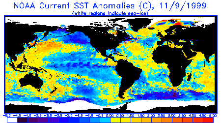
Sea Surface Temperature Anomalies
Courtesy: NOAA
NESDIS
Note the pulses of cold water heading west across the equatorial Pacific, indicative of La
Nina. Also notice much colder than normal conditions off the US West coast and
Alaska (1.0-2.0+ degrees C) and South America extending out to the central Pacific nearly
to New Guinea, caused mainly by strong upwelling driven by brisk easterly trade winds.
These winds are being driven by unusually strong high pressure off the CA coast. Likewise,
notice warmer than normal SST's off Japan and Siberia to north of Hawaii and nearly to
Baja and the entire North Atlantic. In general, this sea surface temperature pattern is
completely out of balance.
 |
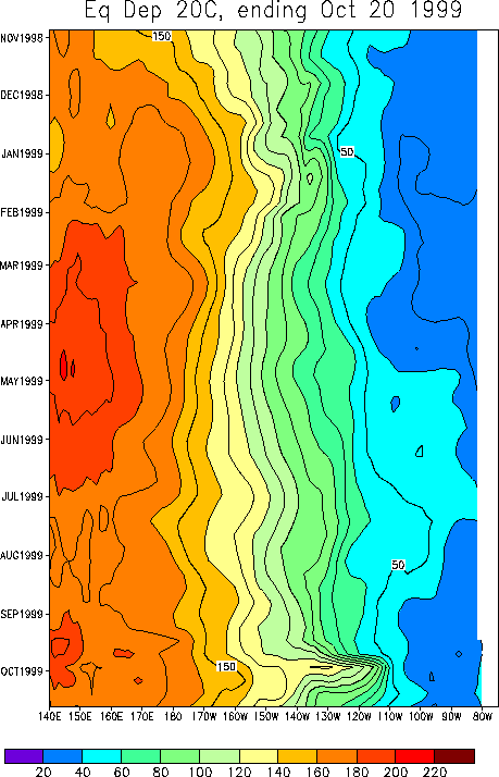
20 Degree Thermocline Depth Time
Series
Courtesy: CPC NCEP NOAA
Warm surface water remains firmly entrenched in the West Pacific and cooler than normal
water temperatures remains locked in the East Pacific. conditions over the
equatorial Pacific. Notice though that in October warm water tried to make a push
towards the East Pacific when the trades temporarily died, but were quickly pushed back
west when trades resumed at above normal strengths.
 |
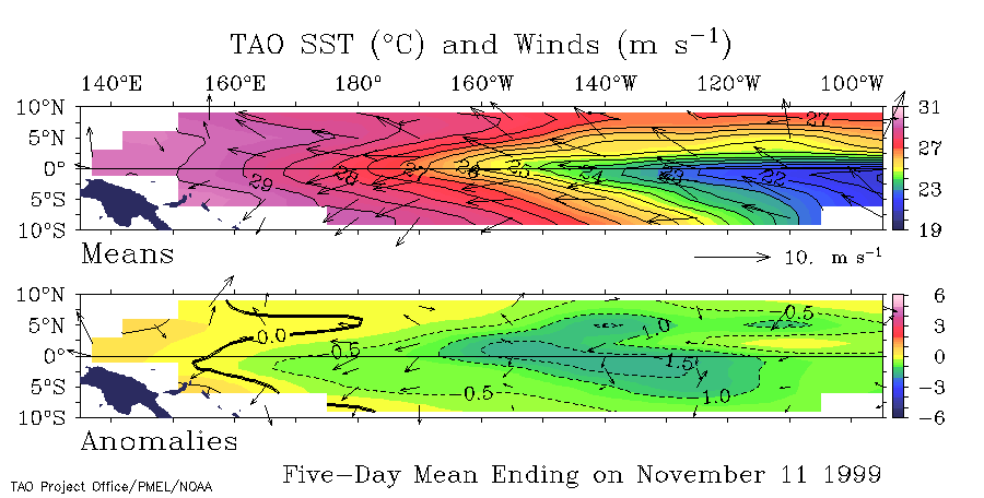
Sea Surface Temperature Anomalies
and Average Surface Winds on the Equatorial Pacific
Courtesy: NOAA PMEL
Notice cooler than normal SST conditions persist over the equatorial Pacific and above
normal trades are blowing warmer waters towards the west and causing upwelling in the
east.
 |
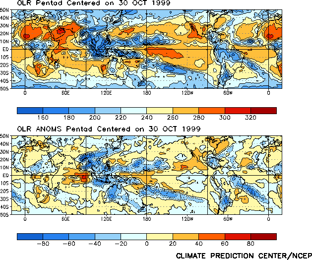
Outgoing Longwave Radiation
(Average and Anomaly)
Courtesy: CPC/NCEP/NOAA
Notice higher than normal cloud reflectivity in the West Pacific, indicative of more
clouds and precipitation, and lower than normal reflectivity in the East Pacific,
indicative of relatively cloud free conditions.
 |
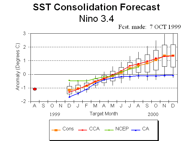
Equatorial Pacific Sea Surface
Temperature Forecast
Courtesy: NOAA/NCEP
Notice that 4 separate models indicate water temperatures over the Central Pacific are not
to return to normal till about May of 2000, but then 3 of the models push well into warmer
than normal conditions, indicative of El Nino
 |
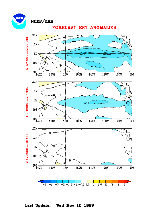
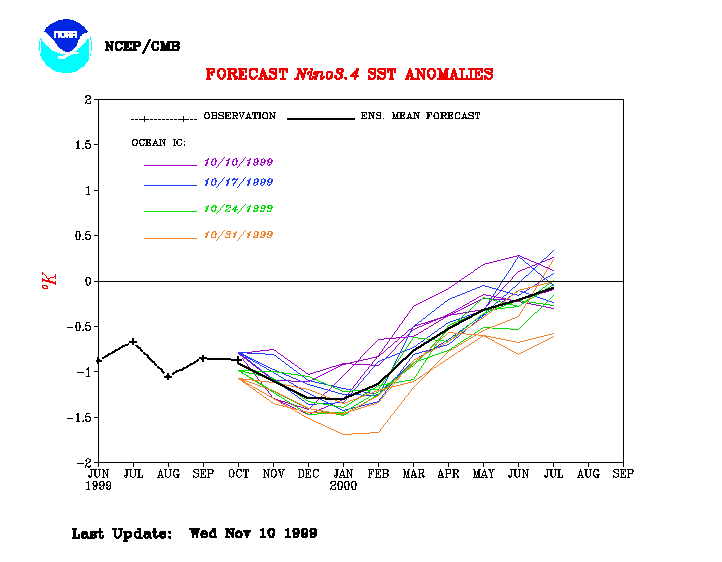
Equatorial Pacific Sea Surface Temp
Forecast
Courtesy: NCEP/CMB
Notice Sea Surface Temps are to remain negative/below normal thru May 2000, then go
neutral, or perhaps warmer than normal by June of 2000, indicative of possible El Nino
development.
 |
|
[an error occurred while processing this directive]
Comments?
webmaster@stormsurf.com