EL NINO SOUTHERN OSCILLATION (ENSO) FORECAST
![]()
EL NINO SOUTHERN OSCILLATION (ENSO) FORECAST
[an error occurred while processing this directive]
Issued: 07/18/2001
Updated As Warranted
See ENSO page for Links and Current Data
EL NINO TRYING TO
DEVELOP
Shift in the Global Weather
Pattern Developing
Neutral conditions dominate the global weather pattern, with an stronger possibility of shifting to weak El Nino conditions by November (2001). Most long-lead forecast models have been projecting a shift to neutral conditions since last year (2000), and current measurements and indices indicate the shift has in-fact occurred, with clear signs that a continued transition towards weak El Nino reasonably possible.
Seasonally adjusted average Sea Surface Temperatures (SST's) across the equatorial Pacific Ocean for May through early July have consistently indicated that warmer surface and sub-surface waters have been moving eastward. For the past 3 years all warm water has been pooled up in the extreme western Pacific, driven there by abnormally strong trade winds (blowing east to west along the equator). This has resulted in cooler than normal water temperatures in the equatorial Pacific and the along the eastern Pacific coastline. But starting in May, a sudden shift in the pattern took.cgiace, with trade winds in the West Pacific turning calm, and even blowing towards the east. One particularly strong burst of easterly winds pushed a large surge of warmer water (known as a Kelvin wave) towards South America. That wave is expected to reach the South American coast in late July. Kelvin waves typically do not occur except during El Nino years. As of this report, average sea surface temperatures along the equatorial Pacific averaged about one half to one degree above normal from well west of the dateline eastward to just north of the Marquesas Islands (about 65% of the way across the Pacific). Surface winds continue to blow anomalously towards the east, extending from the far western Pacific to the Marquesas as well. Sea surface height, that is, the height of the seas surface relative to 'average' is slightly above normal as well covering a thin band almost the entire way across the equatorial Pacific, ranging from 6-16 centimeters above average. Water that is higher than normal is also typically warmer than normal, so this measure further confirms the temperature pattern indicated above.
Looking at the larger scale global picture, waters of the southern hemisphere are generally normal, while the north hemisphere is warmer than normal. In the North Pacific, the warm water horseshoe pattern that has been in.cgiace for the past 3 years, the trademark of the latest La Nina pattern, appears to be breaking down. Still, a large pool of warmer than normal water continues to be evident extending from the Philippines eastward towards the northwest US. But, larger pockets of cooler water are now visible and the streaming pattern is not nearly as defined as in the past.
Of great interest is what has been happening with the Southern Oscillation Index (SOI). The SOI compares relative barometric surface pressure between Darwin, Australia and Tahiti. A positive anomaly indicates La Nina while a negative anomaly indicates El Nino. It started indicating daily negative anomalies in mid-April and continued on that trend through May, and strongly so at times. The SOI index for the month of May averaged -9.9. This is the first time since the onset of La Nina in late '98 that any extended period of negative anomalies have been measured. This means that lower than normal average pressure is building over the Central Pacific while higher than normal pressure is taking hold of the far West Pacific. This condition is what drove development of the Kelvin wave in May. It is also responsible for the prolonged occurrence of high pressure that seems to be blocking the South Pacific-Indian Ocean storm corridor under Australia. Though no good for storm development during this summer, it signals a potential positive shift for the months and years ahead. The negative SOI pattern retreated somewhat during June, with the average SOI up to +2.4. Then in July the trend has been to the negative, with the 30 day running average at -3.1 at report time. Analysis of the MRF model indicates that the tendency towards a slightly negative SOI seem likely through the end of the month. One would want to see a negative SOI to continue typically for 3 months before it could be safely said that some degree of El Nino is in-progress.
Equatorial winds in the far western Pacific continue to blow to the east, a reversal of normal direction. Rather than blowing east to west, they are blowing light to at time moderately west to east. And winds further east along the equator towards the Central and East Pacific appear to have less velocity than the previous 3 years. This would make sense given the change in the SOI mentioned above and the decay of La Nina.
A key indicator in the evolution of either an El Nino or La Nina event is the depth and profile of the 20 degree thermocline. During La Nina events, warm sub-surface water remains pooled up in the far West Pacific near the equator, with cold surface and subsurface waters dominating the East Pacific, resulting in a steep angle from east to west, going from shallow in the east to deep in the west. In El Nino events, warm subsurface equatorial waters migrate towards the eastern Pacific, reducing/flattening the angle. The most recent 20 degree thermocline profile indicates that large subsurface warm water pool that has been entrenched in the West Pacific for 3 years is making some significant progress eastward. A pocket of water up to 3 degrees C above normal is making it's way eastward, and is currently positioned just east of the dateline under the equator. Changes in the sub-surface temperature profile do not occur quickly, especially considering the volume of water that must migrate eastward. The current pattern indicates a return to normal conditions or even slightly toward El Nino.
Outgoing Longwave Radiation (OLR) anomaly data (which measures cloud reflectivity/cloud cover) indicates near normal conditions across the Pacific, a definitive shift from previous years where dryer than normal conditions were prevalent in the East Pacific (over the colder waters) and wetter than normal conditions in the west (over the warmer waters that better support evaporation), typical of La Nina.
Sub-surface sea temperature forecasts from NOAA/NCEP project a slow migration of warm waters from the West Pacific towards the East, maxing in February 2002. In-sync with this pattern, warmer than normal waters on the surface are to become manifest starting in November and continue through March 2002. They are to retreat somewhat over the summer of 2002, then return for a much stronger event in the fall of 2002. Seeing that the sub-surface migration appears to be already in progress, and that the SOI is negative, and that surface winds appear to be changing direction in the far western Pacific, it seems probable that the forecast models are at least pointing in the right direction. Most major forecast models are projecting neutral conditions for the remainder of 2001, with fewer models indicating mild El Nino conditions. Most analysts seem to indicate a major shift is in progress, and that an El Nino event seems likely in 2002.
LONG RANGE NORTH PACIFIC STORM AND SWELL DEVELOPMENT FORECAST
Fall/Winter 2001/2002 Swell Potential Rating (for California) = 6.5
Forecasts data for the winter of 2001/2002 indicates that normal to slightly above normal water temperatures are expected for the equatorial Pacific, indicative of normal to a slightly El Nino configuration. The continued presence of abnormally warm sea surface temperatures in the North Pacific (off Siberia extending to Washington state) will mostly likely remain in.cgiace, though be less prevalent than previous years. The combination of normal to above-normal equatorial surface water temperatures and the warm North Pacific tongue should help to enhance the storm track from Siberia (North Japan/Kuril Islands/Kamchatka Peninsula) into the Gulf of Alaska. This should feed the normal winter storm track, permitting storms to be a bit stronger than normal and take a more southerly track as compared to past years. The additional strength should allow storms to travel further east of the dateline, unlike the winters of 1998 - 2000, where high pressure generally had a stronger grip on the Gulf region and forced many storms into the Aleutian Islands, obscuring their swell producing winds. The result of this enhanced storm track would be larger and more consistent swells, but the pattern could also bring stormier conditions to the western US coast.
(This forecast is highly speculative and based on historical analysis of past La Nina/El Nino events and the latest long-range forecast models)
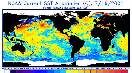
Sea Surface Temperature Anomalies
Courtesy: NOAA NESDIS
Notice that generally warmer waters are
covering the equatorial Pacific from the far west almost continuously eastward to Central
and South America. A large area of warmer than normal water in the northern
hemisphere still extends from the Philippines to the northwest US, but it is much less
defined as in previous months and pockets of colder water (blue) are now
interspersed.
 |
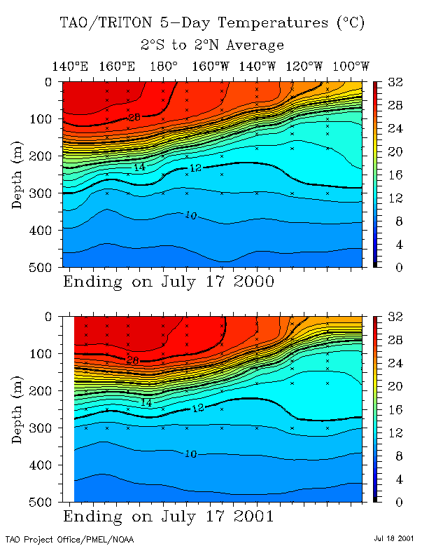
20 Degree Thermocline Depth and
Position Time Series
Courtesy: CPC NCEP NOAA
Warm sub-surface water is still entrenched in
the West Pacific, but has made significant eastward progress since last year and even over
the past 6 months.
 |
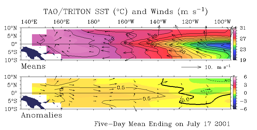
Sea Surface Temperature Anomalies
and Average Surface Winds on the Equatorial Pacific
Courtesy: NOAA PMEL
Notice warmer than normal SST conditions
currently ( +0.5-1.0 degrees C) cover the entire equatorial Pacific region from the far
west to almost 120W. Also notice anomolously neutral winds over the equator in the Central
Pacific and that the trades have died in the far West Pacific, and have been r.cgiaced by
winds blowing towards the east.
 |
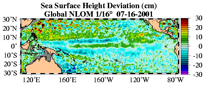
Sea Surface Height Deviation
Courtesy: NLOM
Notice that seas heights are higher than
normal in a thin band just north of the equator from the West Pacific to almost Central
America. The same pattern is present directly over the equator too, with a small
return (lower than normal) stream .cgiitting the flow.
 |
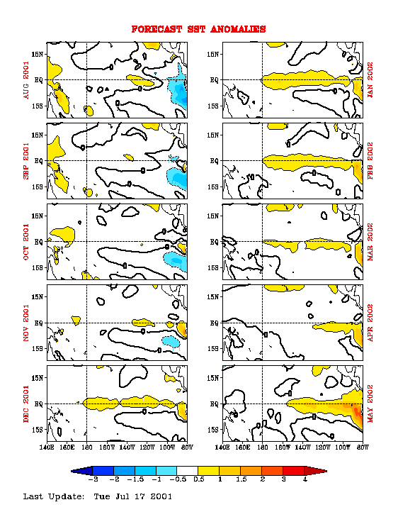
Equatorial Pacific Sea Surface
Temperature Forecast
Courtesy: NOAA/NCEP
Notice that 4 separate models runs (using
different starting conditions) indicate water temperatures over the Central Pacific are to
remain steady well into next year.
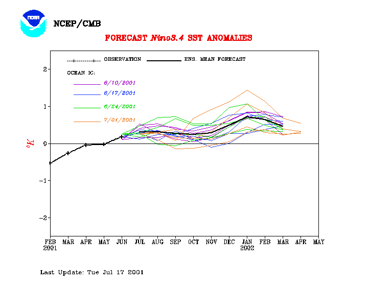 |
Equatorial Pacific Sea Surface Temp
Forecast
Courtesy: NCEP/CMB
Notice Sea Surface Temps are to remain generally
neutral until November 2001, then go slightly warm along the equator through March 2002,
and then back off a bit until May 2002.
 |
10564
Comments?
webmaster@stormsurf.com
Last Modified: 09/18/01 09:00 PM