Here's a quick look at what's to come per the CFS model. There are 3 images in the sequence. All are based on the ensemble mean (4 members) from 7N to 7S. Individual member output varies from the mean. Images courtesy of Kyle Macritchie. For all three images: Past history is below the black horizontal line in the middle of the chart. The forecast is above the black line. The image spans the entire planet from left to right with the international date line running down the middle of the chart vertically. The Kelvin Wave Generation area is from 130E-170W or roughly just left of the center of the image.
Image #1
The first image below depicts the U component of the 850 mb winds. The U component is the zonal component, or east-west direction only (ignoring north or south). Said another way, orange/reds are westerly wind anomalies. The more red the coloration the stronger the velocity and greater the likelihood of it being a Westerly Wind Burst (WWB). Yellows could be interpreted to be just anomalies. Blues are easterly anomalies. The 850 mb level is up at about 4,500 ft, but is typically assumed to be a good proxy for what is occurring down at the oceans surface. Notice the 3 past WWBs are clearly visible below the horizontal line (March, May and early July). The thing to take notice of here is that per the model, from today forward, westerly anomalies are to continue at least through early Oct. There is no projection for easterly anomalies in the KWGA. This is very good news suggesting that much more warm water will get pushed to depth and continue the flow into a now well established warm reservoir in the equatorial East Pacific. If the last bit of westerly anomalies are in October, the resulting Kelvin Wave would not arrive in Ecuador till early January 2016.
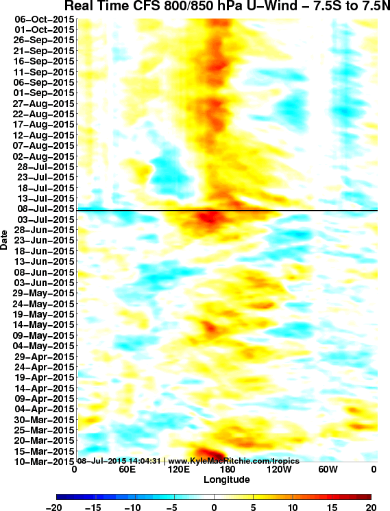
Image #2
: This image depicts the forecast for the MJO. Solid red lines are the Active Phase, dotted lines the Inactive Phase. Notice an Inactive Phase is scheduled for late July into early August in the KWGA. This is consistent with other models output. Also notice an Active pulse is to follow in mid-September.
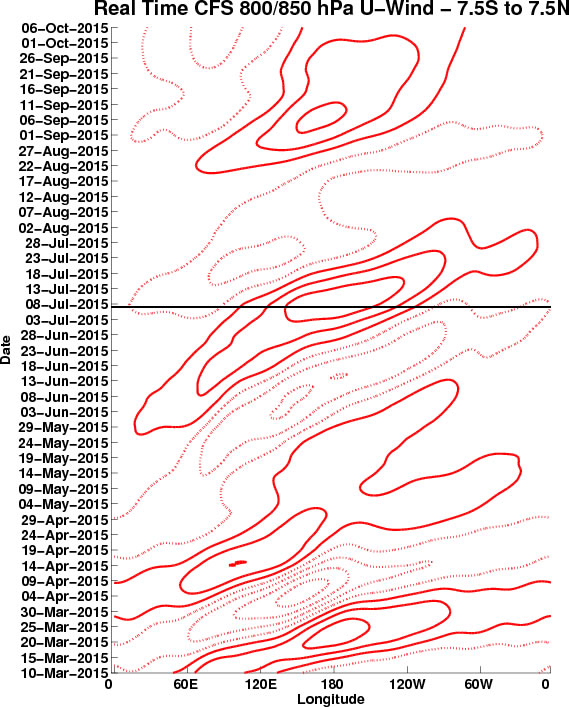
Image #3
And finally the combination of the two. Notice that even during the Inactive Phase in early August westerly anomalies are to persist. and then be enhanced some by the Active Phase that follows. This is consistent with our recollection of the '97 event in that in the later stages of the El Nino lifecycle, westerly winds become persistent, and less influenced by the MJO, with the MJO almost appearing to dissipater. That is becuase the El Nino base state becomes so entrenched (assuming it is strong enough) that the MJO begins to have almost no influence. This would be a hallmark sign of a strong El Nino. 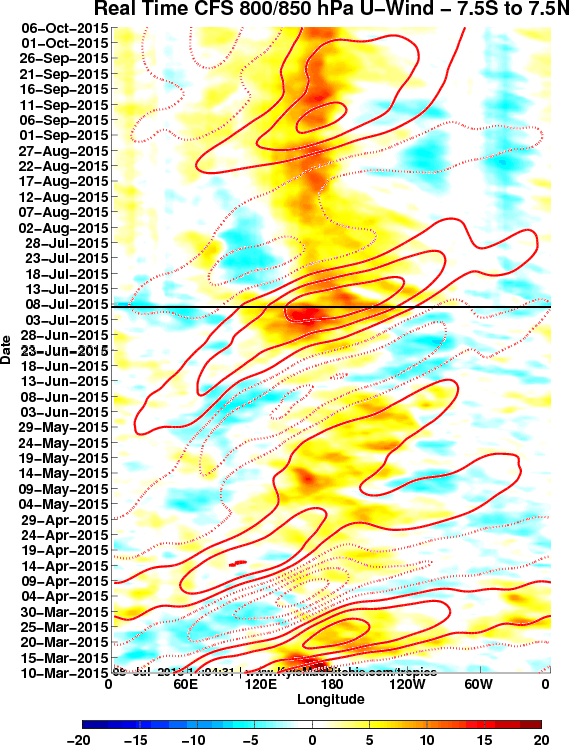
But again the usual word of caution - This is just a forecast produced by a computer and does not mean this outcome will actually occur. Still, the CFS has been tracking pretty close to reality this year, lending credence to the thought that the above outcome is becoming more possible. And that suggests that if this forecast validates, a stronger than normal El Nino may result.
|
